Summary
Severe Tropical Cyclone Lam crossed the east Arnhem land coast of Northern Territory on 19 February 2015 as a category 4 system. Lam caused significant damage to infrastructure and vegetation at Galiwin'ku, Milingimbi, Ramingining and nearby outstations on the mainland. Impacts included: loss of power, water and communications; contamination of water supplies by sewerage overflows; uninhabitable houses; and blocked access roads. Remarkably no deaths and only a few minor injuries were recorded. Several residents reported that severe tropical cyclone Lam was the worst in living memory, apart from those who had experienced Cyclone Tracy in Darwin, in 1974. Nhulunbuy and the Gove Peninsula escaped significant damage as Lam passed further to the north.
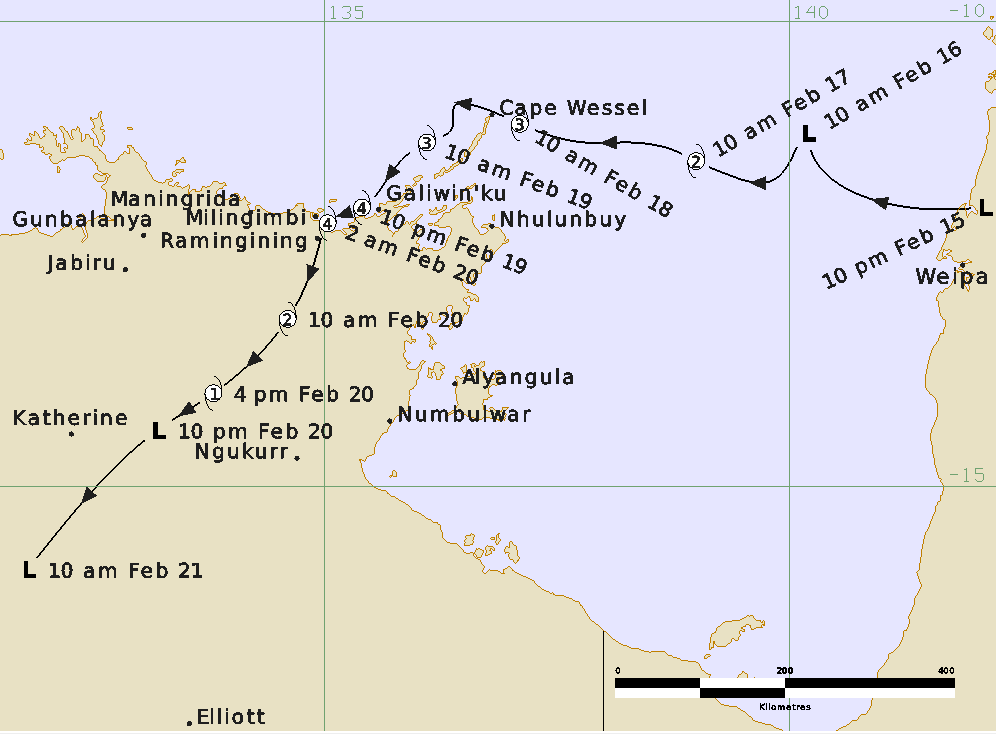
A tropical low developed over Cape York Peninsula on 15 February 2015 and moved west over the Gulf of Carpentaria. It then developed quickly reaching tropical cyclone intensity early on 17 February and then category 3 intensity on 18 February as it approached the Wessel Islands, north of Nhulunbuy. The slow movement of Lam resulted in Cape Wessel recording gales for 30 hours with a four-hour lull as the eye passed over the station. A minimum pressure of 971.1 hPa was recorded at and the maximum recorded wind gust was 170 km/h.
Severe tropical cyclone Lam turned towards the southwest on 18 February and intensified further to category 4 intensity later on 19 February as it passed just to the west of Galiwin'ku, on Elcho Island. Gales affected Elcho Island for approximately 21 hours and although wind gusts reached 174 km/h, fortunately the inner eyewall of the cyclone remained just offshore.
Lam crossed the mainland coast early on 20 February as a category 4 severe tropical cyclone, about 15 km northeast of Ramingining and 20 km southeast of Milingimbi. Radars at Gove and Warruwi indicated that the eye wall may have contracted prior to landfall—a circular eye of 14 km in diameter was observed just to the east of Ramingining.
Lam weakened rapidly as it moved southwest over central Arnhem Land and was downgraded below tropical cyclone strength late on 20 February. The tropical system produced heavy rain over parts of the Arnhem, Carpentaria, Daly and Gregory forecast districts. This contributed to moderate flooding of the Waterhouse River at Beswick Bridge.
For more information see the TC Lam Report (pdf).
Track and Intensity