Summary
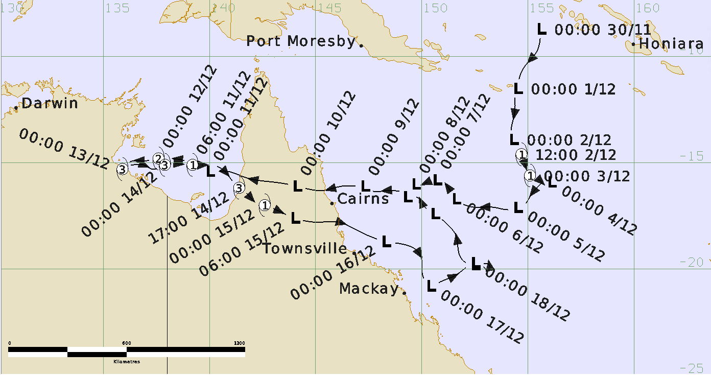
Severe tropical cyclone Owen was a long-lived, early season system that moved from the Coral Sea into the Gulf of Carpentaria and back again. Owen reached tropical cyclone intensity on two occasions during its lifetime, although it produced most of its impacts as a tropical low.
The precursor tropical low was identified and tracked in the Solomon Sea from 30th November. The system moved south into the Coral Sea and reached tropical cyclone intensity on 2 December. Tropical Cyclone Owen moved to the southeast as a category 1 cyclone but weakened below cyclone intensity some 30 hours later.
The tropical low then turned west and crossed the north Queensland coast early on 10th December near Port Douglas. Cairns and Innisfail recorded wind gusts to 47 kn (87 km/h). Strong winds brought trees down at Yarrabah, east of Cairns. Heavy rains also accompanied the system's landfall causing some flooding of local rivers and creeks.
The low crossed Cape York Peninsula and emerged into the Gulf of Carpentaria overnight from 10th to 11th December. Later, on 11th December Owen redeveloped into a tropical cyclone and intensified as it tracked westwards. Owen reached peak intensity as a category 3 system just as it made landfall on an uninhabited stretch of the southwestern Gulf coast, northeast of Port McArthur in the Northern Territory on the morning of 13th December.
Owen then turned back towards the east, virtually retracing its steps across the Gulf of Carpentaria. It maintained category 3 but weakened slightly before making landfall again on the southwestern Cape York Peninsula coast, north of the Gilbert River Mouth, early on 15th December. During this phase, Owen was notable for its tiny eye – not clearly visible on satellite imagery, but less than 20 km across on radar. As a result of this, the peak winds associated with Owen were very localised and the Centre Island AWS on the periphery of the cyclone recorded just 3 hours of gale force winds with a peak gust of 49 kn (91 km/h). There were no significant impacts to populated areas apart from several remote roads cut by floodwaters. The residents of King Ash Bay and Bing Bong near Port McArthur were evacuated to Borroloola during the event.
Owen weakened to a tropical low for the final time as it crossed the base of Cape York Peninsula during 15th December before moving off the north tropical Queensland coast between Innisfail and Cardwell. Its passage was accompanied by torrential rain, particularly at Halifax (east of Ingham) where an Australian record for December of 681 mm fell in the 24 hours to 9am AEST on the 16th. The Bruce Highway was cut north of Ingham. Two rescues occurred, including a mother and daughter rescued from their vehicle in crocodile-infested floodwaters. Sugarcane crops were impacted and hundreds of chickens were lost to flooding. Lucinda also recorded a 54 kn (100 km/h) wind gust as ex-Owen moved offshore.
After moving back into the Coral Sea, the remains of Owen persisted as a tropical low for several days but did not re-form into a tropical cyclone.
For more information see the Owen 2018 Report (pdf).
Track and Intensity