This page provides details about the region, its water resources, land use and water-related infrastructure.
Area: 5,340 km²
Population: 1,300,000 (ABS 2011)
The Adelaide region is located in the southeast of South Australia, on the east coast of the Gulf St Vincent (Figure P1). It extends from the Barossa Valley in the north to the Fleurieu Peninsula in the south and includes metropolitan Adelaide, the Northern Adelaide Plains and the Western Mount Lofty Ranges (Figure P2). The terrain in the region ranges from flat plains near the coast to steep hills in the east and south.
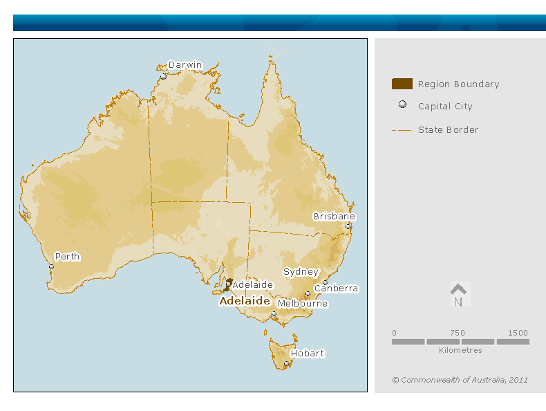
Figure P1. Location map of the Adelaide region within Australia
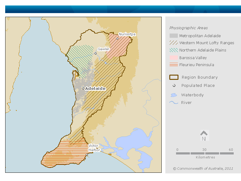
Figure P2. Contextual map of the Adelaide region
The main catchments in the Adelaide region (Figure P3) are:
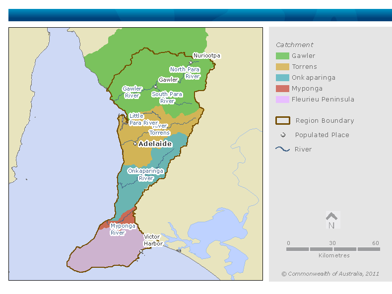
Figure P3. Map of surface water catchments in the Adelaide region
The major cities and towns in the region, along with their population (ABS 2011), are:
The Adelaide region is physically defined by the catchments that intersect the Adelaide and Mount Lofty Ranges Natural Resource Management (NRM) region, specifically the Fleurieu Peninsula, Myponga, Onkaparinga, Torrens and Gawler catchments (excluding the Light sub-catchment).
The region includes water stored in and transactions related to:
The region excludes water stored in and transactions related to:
For more information regarding items in this water accounting report, please refer to the significant water accounting policies.
The dominant land use in the region is agriculture and urban. Further information on land use in the Adelaide region is provided in Table P1 and Figure P4. There are five irrigation districts in the region. Much irrigation water is self-extracted. There is one irrigation scheme delivering water from a prescribed water source and two significant irrigation schemes delivering recycled water. Irrigation water is used for viticulture, horticulture and irrigated pasture.
Overall, manufacturing is not a large user of water in the Adelaide region although some manufacturers are locally intensive water users. Major water intensive industries include wineries, brewing, beverage production, food and fibre processing, concrete and soda production (AMLRNRMB, 2008; Ryan, 2008; Zulfic, Osei-Bonsu & Barnett 2008).
Table P1. Land use in the Adelaide region
|
Land use |
Area (km2) |
Area (% of total) |
|---|---|---|
|
Conservation and natural environments |
718 |
14 |
|
Grazing |
1,826 |
34 |
|
Forestry |
160 |
3 |
|
Dryland agriculture |
836 |
16 |
|
Irrigated agriculture |
488 |
9 |
|
Urban |
1,089 |
20 |
|
Other intensive uses |
73 |
1 |
|
Mining |
17 |
<1 |
|
Water |
125 |
2 |
|
Total |
5,332* |
~100 |
Source:ABARES 2010
* This area is less than the total region area reported in General Description above due to the spatial resolution of the land use data.
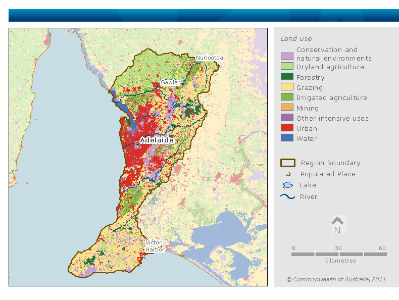
Figure P4. Map of land use in the Adelaide region
The region contains several nationally significant wetlands listed in the Directory of Important Wetlands in Australia (Table P2).
Table P2. Nationally significant wetlands in the Adelaide region
|
Wetland |
Description |
|---|---|
|
Ecosystems dependent on waterlogged and peat soils maintained by surface and groundwater inflows |
|
|
Open forest and swamp ecosystems |
|
|
Freshwater coastal lagoon |
|
|
|
Estuarine ecosystem with tidal swamps |
|
Estuarine ecosystem on mud flats and mangrove swamps |
|
|
Significant marine ecosystem on mud flats and mangrove swamps |
|
|
Ecosystems dependent on waterlogged and peat soils
|
|
Source: DSEWPC 2011
Water used in the region comes from the following sources:
Some surface resources within the region are fully developed, while others have scope for further development (AMLRNRMB 2011). Groundwater resources are generally fully developed; some groundwater resources of the Northern Adelaide Plains and Mt Lofty Ranges are considered to be over-developed (AMLRNRMB 2011).
Recycled stormwater and wastewater are used increasingly for agricultural and municipal irrigation, and industrial purposes. There is scope for further development of recycled water; policies are in place to support this occurring.
Table P3. Surface water infrastructure in the Adelaide region
|
Infrastructure |
Operation |
Major use |
Operator |
|---|---|---|---|
|
Barossa Infrastructure Limited (BIL) scheme |
River Murray water delivered from Warren Reservoir to private irrigators |
Irrigation |
Barossa Infrastructure Limited |
|
Mannum-Adelaide pipeline |
Delivers water from River Murray into Torrens catchment |
Urban |
SA Water |
|
Murray Bridge-Onkaparinga pipeline |
Delivers water from River Murray into Onkaparinga catchment |
Urban |
SA Water |
|
Swan Reach-Stockwell pipeline |
River Murray water supplied to the Barossa Valley and northern Adelaide as well as to urban areas outside the Adelaide region |
Urban and irrigation |
SA Water |
|
Metropolitan Adelaide water supply system |
Delivers potable water from reservoirs via storage tanks and treatment plants |
Urban |
SA Water |
|
Metropolitan Adelaide wastewater system |
Delivers wastewater to Adelaide wastewater treatment plants |
Urban |
SA Water |
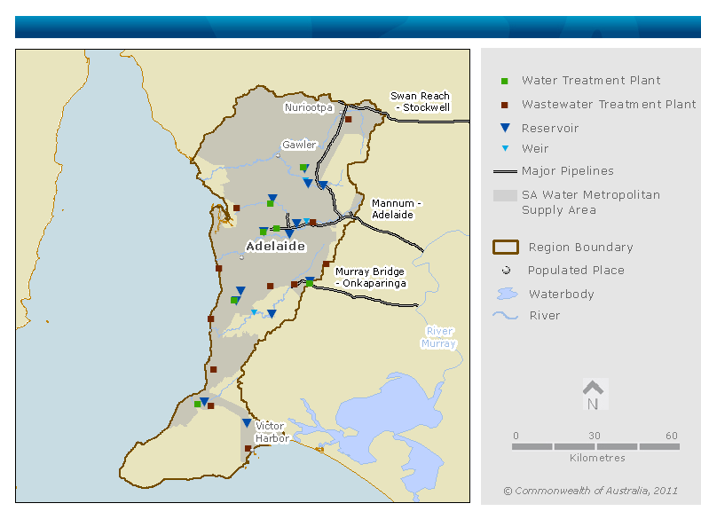
Figure P5. Map of surface water infrastructure within the Adelaide region
SA Water manages an extensive network of water storages in the Adelaide region for urban water supply. Information about these storages is presented in Table P4.
Table P4. Major water storages in the Adelaide region
|
Water storage |
Total storage capacity (ML) |
Dead storage capacity (ML) |
Purpose |
|---|---|---|---|
|
Mount Bold Reservoir |
45,900 |
27 |
Urban – supplements other storages |
|
South Para Reservoir |
44,847 |
310 |
Urban – supplements other storages |
|
Myponga Reservoir |
26,993 |
163 |
Urban |
|
Little Para Reservoir |
20,800 |
188 |
Urban |
|
Kangaroo Creek Reservoir |
19,000 |
300 |
Urban – supplements other storages |
|
Millbrook Reservoir |
16,500 |
188 |
Urban – supplements other storages |
|
Happy Valley Reservoir |
12,700 |
71 |
Urban |
|
Warren Reservoir |
4,780 |
0 |
Urban – supplements other storages |
|
Barossa Reservoir |
4,510 |
19 |
Urban |
|
Hope Valley Reservoir |
2,764 |
123 |
Urban |
|
Total |
198,794 |
1389 |
- |
Mean monthly streamflow pattern, volumes and variation at three rivers in the Adelaide region are shown in Figure P6. The locations used to generate these figures are:
Figure P7 provides the location of the stream gauges used to prepare these hydrographs.
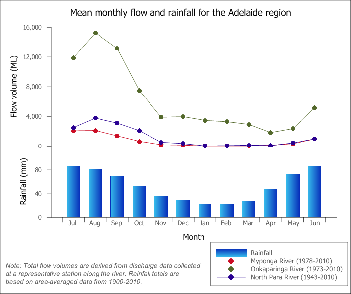
Figure P6. Monthly streamflow graphs for North Para (A5050502), Myponga (A5030504) and Onkaparinga (A5020502) rivers; mean monthly rainfall is also shown
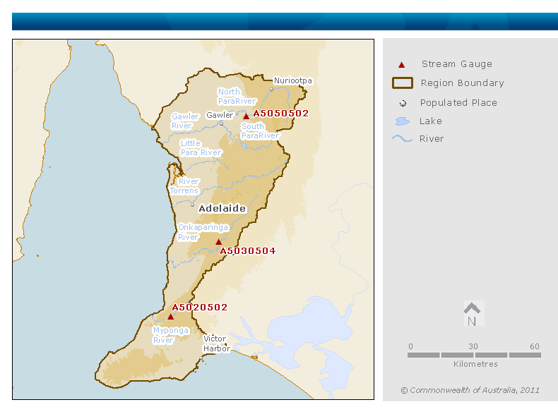
Figure P7. Map of key flow gauging stations along the main rivers within the Adelaide region
Groundwater is an important water resource in the Adelaide region both for irrigation and for stock and domestic supply. The major groundwater resources are:
Groundwater generally flows west from the higher rainfall recharge areas in the Western Mount Lofty Ranges towards the St Vincent Basin (Stewart, Banks & Wilson 2009). Lateral flow is the main mechanism for recharge of the coastal aquifers.
Significant areas of groundwater use and groundwater management areas are presented in Table P5.
Table P5. Significant areas of groundwater use and groundwater management areas in the Adelaide region
|
Groundwater area |
Groundwater management area |
Hydrogeology |
Primary use |
|---|---|---|---|
|
Barossa Valley
|
Barossa Valley prescribed water resource area |
Confined, unconfined and fractured rock aquifers |
Viticulture |
|
Northern Adelaide Plains
|
Northern Adelaide Plains prescribed wells area
|
Mostly confined aquifers |
Mixed horticulture, industrial |
|
Central Adelaide
|
Central Adelaide prescribed wells area |
Confined, unconfined and fractured rock aquifers |
Mixed horticulture, industrial, domestic, irrigation of recreational areas |
|
Adelaide Hills
|
Western Mount Lofty Ranges prescribed water resources area |
Mostly fractured rock aquifers |
Mixed horticulture, irrigated pasture, viticulture |
|
McLaren Vale
|
McLaren Vale prescribed wells area, Western Mount Lofty Ranges prescribed water resources area |
Confined, unconfined and fractured rock aquifers |
Viticulture, horticulture |
|
Southern Fleurieu Peninsula
|
Western Mount Lofty Ranges prescribed water resources area |
Mostly fractured rock aquifers with some confined and unconfined aquifers |
Mixed horticulture, irrigated pasture, viticulture |
Recycling of wastewater is increasingly significant to the Adelaide region. Approximately 30% of the wastewater treated by SA Water is used in recycled water applications (OWS 2010). Community Wastewater Management Systems (CWMS) are another source of treated wastewater; they are typically operated by local councils and harvest water from household septic systems. The most significant recycled wastewater schemes in the Adelaide region are presented in Table P6.
Table P6. Recycled waste water schemes in the Adelaide region
|
Recycling facility |
Volume – approx |
Purpose |
Operator |
|---|---|---|---|
|
Aldinga treatment plant |
300 ML/year |
Irrigation of vines |
SA Water |
|
Bird-in-Hand |
100 ML/year |
Irrigation |
SA Water |
|
Bolivar treatment plant |
18,000 ML/year |
Mainly agricultural irrigation (Virginia pipeline scheme), some municipal irrigation and dual reticulation at Mawson Lakes |
SA Water, United Water |
|
Christies Beach treatment plant |
3,500 ML/year |
Irrigation of vines (through the Willunga Basin recycled water pipeline operated by Willunga Basin Water Company) |
SA Water |
|
Glenelg treatment plant |
2,000 ML/year |
Irrigation of parks and recreation facilities (Adelaide Park Lands pipeline) |
SA Water |
|
Golden Grove |
Up to 280 ML/year (not yet supplying at capacity) |
Irrigation of parks and recreation facilities |
CWMS* |
|
Greenock, Kapunda, Freeling, Roseworthy |
180 ML/year |
Irrigation of vines |
CWMS* |
|
Kersbrook, Birdwood/Mount Torrens, Charleston, Woodside, Verdun |
Unknown |
Irrigation of woodlands |
CWMS* |
|
Myponga, Yankalilla, Second Valley |
Unknown |
Irrigation |
CWMS* |
|
NPEC Wastewater treatment plant |
250 ML/year |
Irrigation (reuse of winery wastewater) |
North Para Environmental Control (NPEC) |
|
Nuriootpa, Lyndoch, Penrice, Mount Pleasant, Tanunda, Williamstown, Springton |
700 ML/year |
Irrigation of vines |
CWMS* |
|
Other SA Water treatment plants (e.g. Angaston, Gumeracha) |
Individual capacity <100 ML/year |
Irrigation |
SA Water |
|
Victor Harbor treatment plant |
150 ML/year |
Irrigation of horticulture and parks |
SA Water |
|
Willunga CWMS* |
340 ML/year |
Irrigation of vines and recreational facilities (through the Willunga Basin recycled water pipeline operated by Willunga Basin Water Company) |
CWMS* operated by the City of Onkaparinga |
*CWMS: Community Wastewater Management System
Source: The Barossa Council website; Kelly, Stevens & White 2003; Council staff at various councils, pers. comm.; SA Water unpublished WTP records, 2010
Stormwater harvesting (collection, treatment and use of urban run-off) is also of increasing importance to the Adelaide region. Stormwater schemes are typically operated by councils and involve treating stormwater through constructed wetlands and storage in the aquifer. The current capacity of council stormwater schemes is 7300 ML/year, but many new schemes are in development (OWS 2010; SMA 2009). Treated stormwater is generally used for municipal irrigation and industrial processes, such as wool washing.
There are more than 25 private and publicly owned desalination plants with an individual capacity greater than 1.8 ML/year in the region. Unlike other regions of Australia, desalination is not currently used to treat sea water and supplement the urban potable water supply system. However, a 100 GL desalination plant at Port Stanvac is under construction and due for completion in late 2012. Desalination is typically used to improve groundwater, wastewater and mains water quality on a small scale to a standard suitable for irrigation, industry and medical purposes. Desalination of groundwater for food, beverages and industrial processes constitutes 95% of the capacity of desalination plants in the region.
Dewatering of aquifers occurs in the Adelaide region to facilitate mining, quarrying and construction activities. Depending on water quality, the water is stored in above ground storages, discharged into nearby watercourses or aquifers, or applied to the landscape.
National Water Account 2010
Related links
Water links
