This page provides details about the region, its water resources, land use and water-related infrastructure.
Population: 2.0 million ( Australian Bureau of Statistics 2008)
The Murray–Darling Basin (MDB) is defined by the catchment areas of the Murray and Darling rivers and their many tributaries. The MDB covers three-quarters of New South Wales, more than half of Victoria, significant portions of Queensland and South Australia, and all of the Australian Capital Territory (shown in figures P1 and P2). It contains:

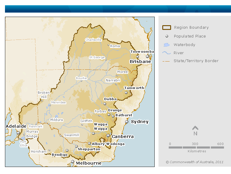
Figure P2. Contextual map of the Murray–Darling Basin (source for the boundaries of the MDB: Australian Government Department of Sustainability, Environment, Water, Population and Communities)
Major rivers in the MDB include (Geoscience Australia 2010):
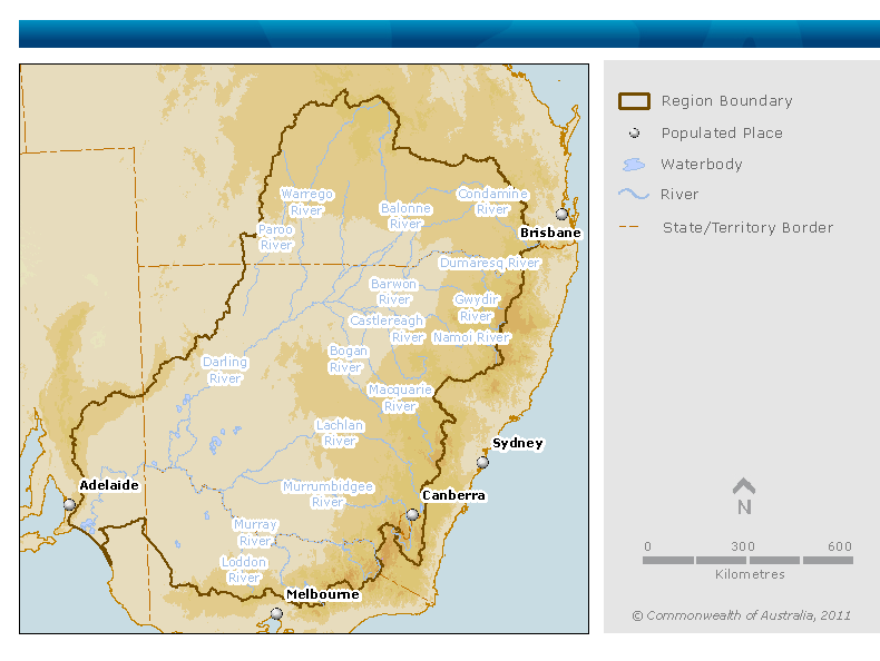
Figure P3. Map of major rivers of the Murray–Darling Basin (source for the boundaries of the MDB: Australian Government Department of Sustainability, Environment, Water, Population and Communities)
The MDB is defined in Section 18A of the Water Act 2007 (Cwlth). It includes all water resources within or beneath the MDB, but does not include groundwater that forms part of the Great Artesian Basin (GAB).
For the National Water Account 2010 (the 2010 Account), the MDB region (see Figure P2) is defined as all the surface water connected to the channel network and all the groundwater (excluding any water in the GAB) located within the geographical boundaries of the MDB specified by the Australian Capital Territory, less:
In particular, the following elements are not included in the MDB region:
The MDB region presents a varied landscape, from semi-arid ephemeral river systems in the north to highly regulated river systems in the south fed from the Australian Alps. To the east and south, the highlands of the Great Dividing Range form the limit of the MDB region, while in the north, west, and southwest, the boundaries are much less distinct. The greater proportion of the MDB region is made up of extensive plains and low undulating areas; most of them are less than 200 m above sea level.
The major land use activities in the MDB region are shown in Table P1 (Australian Bureau of Rural Science 2010). Figure P4 shows the distribution of these land uses within the region.
| Land use activity |
Area (km2) |
Total area of region (%) |
|---|---|---|
| Conservation and natural environments |
107,600 |
10 |
| Dryland agriculture |
133,300 |
13 |
| Forestry |
34,000 |
3 |
| Grazing |
727,800 |
69 |
| Irrigated agriculture |
24,700 |
2 |
| Mining |
300 |
<1 |
| Other intensive uses |
1,200 |
<1 |
| Urban |
14,300 |
1 |
| Water |
12,400 |
1 |
| Total |
1,055,600 |
100 |
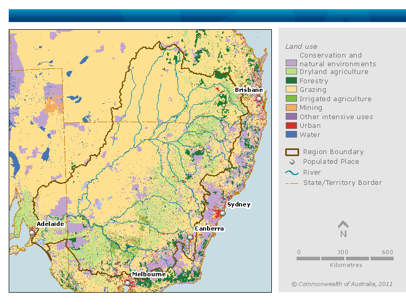
Figure P4. Map of land use in the MDB region (source: Australian Bureau of Rural Science 2010; source for boundaries of the MDB region: Australian Government Department of Sustainability, Environment, Water, Population and Communities)
Land use activities that are major water users in the MDB region are urban supply and irrigated agriculture.The water resources in the MDB region are highly developed, as illustrated by the following statistics based on a long-term average of 114 years (1895–2009) (source: Guide to the Proposed Basin Plan):
A Murray–Darling Basin Cap (the Cap) was established in 1995 to limit the volume of surface water that could be diverted in the MDB region in any year to that based on the 1993–1994 levels of development. The Cap does not place a restriction on groundwater extraction. See ‘Operating rules and constraints’ within the ‘Water rights’ section for further information on the Cap.
The northern part of the MDB region consists mostly of unregulated systems, where many of the rivers and streams are ephemeral and fed by seasonal rainfall. Generally, water users in much of the northern MDB region must rely on collecting water during floods and storing it on-farm for later use.
The accounting reports for the 2010 Account present details on the surface water volumes for the 19 regions (see Figure P5) as defined for the proposed Basin Plan where data were available.

Figure P5. Map of Murray–Darling Basin Plan’s regions (source: Murray–Darling Basin Authority)
The total storage capacity (including dead storage) for the 50 major storages (excluding weirs) within the MDB region for which data are available for the 2010 Account is 23,097,214 ML. A full list of these storages and their individual storage capacities can be found in:
Figures P7 to P9 show streamflow patterns, volumes and variations at three major rivers in the region for the following streamflow gauging stations shown in Figure P6:
The Darling River at Bourke represents the unregulated northern MDB region.
The Murray River at Doctors Point (Albury) represents a regulated reach of the Murray downstream of the major regulating reservoirs.
The Ovens River at Peechelba represents a largely unregulated major river in the southern MDB region.
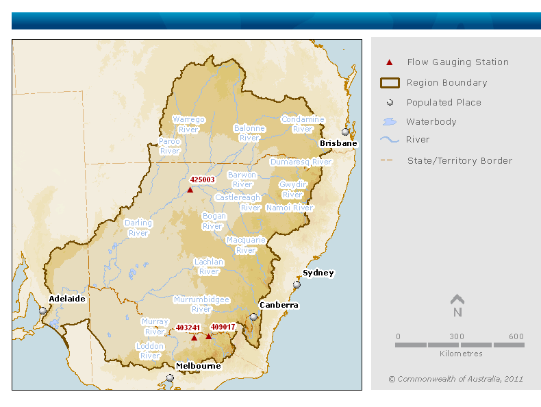
Figure P6. Map of the streamflow gauging station locations used to develop flow charts (sources: Bureau of Meteorology and Murray–Darling Basin Authority)
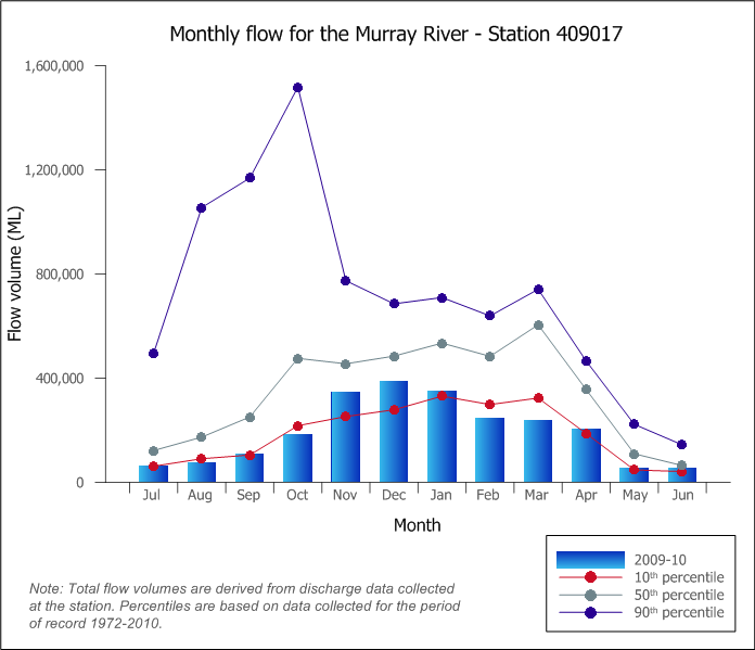
Figure P7. Graph of total monthly flow during 2009–10 compared against long-term percentiles for the Murray River at Doctors Point (Albury) (Source: Bureau of Meteorology)
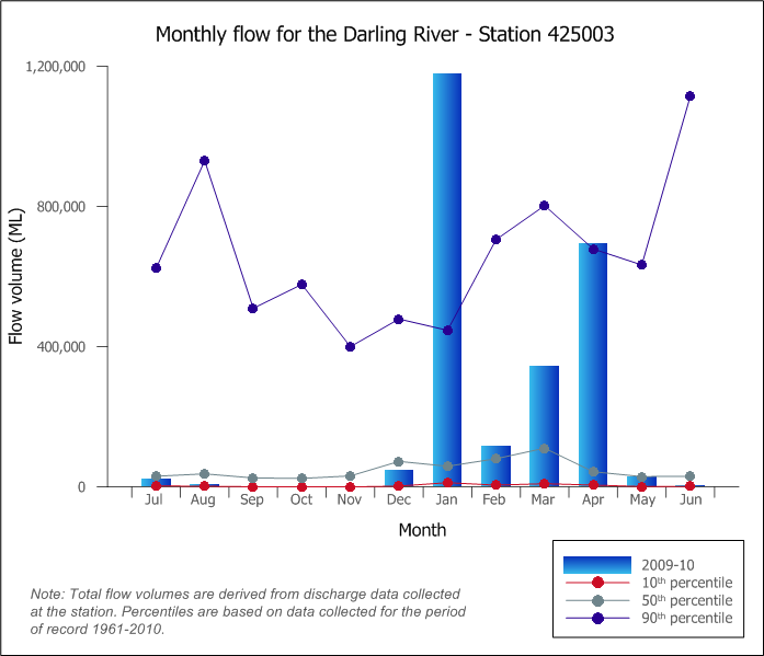
Figure P8. Graph of total monthly flow during 2009–10 compared against long-term percentiles for the Darling River at Bourke (Source: Bureau of Meteorology)
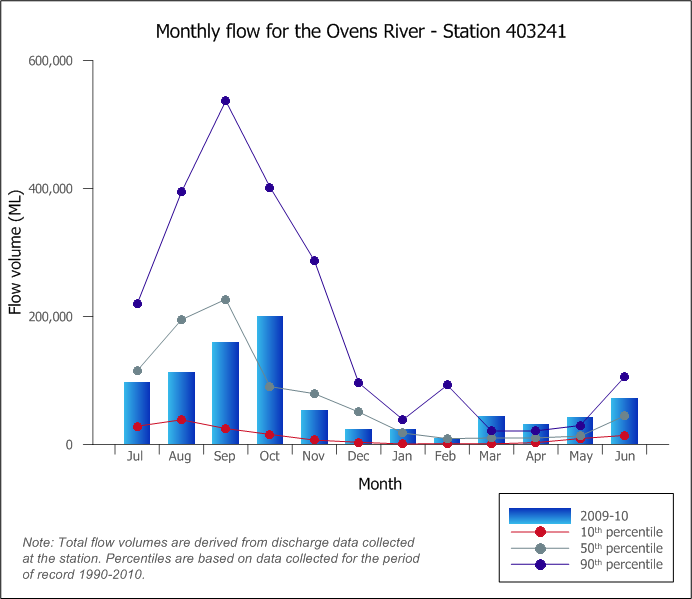
Figure P9. Graph of total monthly flow during 2009–10 compared against long-term percentiles for the Ovens River at Peechelba (Source: Bureau of Meteorology)
In a number of locations, water is transferred into or out of the region, as well as from one catchment to another within the region (see Figure P10).
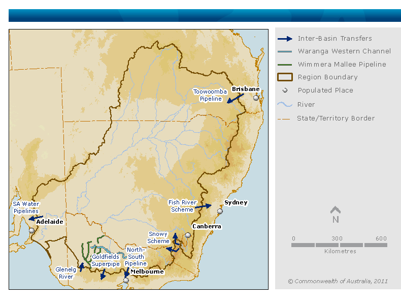
Figure P10. Map of water transfers into, out of, or between catchments within the MDB region (sources: Bureau of Meteorology and Murray–Darling Basin Authority)
Major transfers into the MDB region are from:
Transfers out of the MDB region include diversion of water from the:
Channels and pipelines in the river system of the southern MDB region allow water to be moved and traded from one catchment to another. For example, the Waranga Western Channel delivers water from the Goulburn River to the Campaspe, Loddon and Wimmera–Avoca catchments.
The groundwater systems of the MDB region can be categorised into three broad types:
|
No. |
Groundwater management unit (GMU) |
State |
|---|---|---|
| 1 |
Lower Gwydir Alluvium |
NSW |
| 2 |
Lower Lachlan Alluvium |
NSW |
| 3 |
Upper Lachlan Alluvium |
NSW |
| 4 |
Lower Macquarie Alluvium |
NSW |
| 5 |
Lower Murray Alluvium |
NSW |
| Lower Murrumbidgee GMUs – sum of GMUs 6 & 7 |
||
| 6 |
Lower Murrumbidgee Deep Groundwater source |
NSW |
| 7 |
Lower Murrumbidgee Shallow Groundwater source |
NSW |
| 8 |
Mid Murrumbidgee Alluvium |
NSW |
| 9 |
Lower Namoi Alluvium |
NSW |
| 10 |
Upper Namoi Alluvium |
NSW |
| Katunga–Campaspe GMUs – sum of GMUs 11–13 |
||
| 11 |
Campaspe Deep Lead Water Supply Protection Area |
Vic |
| 12 |
Katunga Water Supply Protection Area |
Vic |
| 13 |
Shepparton Irrigation Water Supply Protection Area |
Vic |
| 14 |
Mid Loddon Water Supply Protection Area |
Vic |
| Lower Murray–Darling Basin GMUs – sum of GMUs 15–27 |
||
| 15 |
Balrootan (Nhill) Groundwater Management Area |
Vic |
| 16 |
Goroke Groundwater Management Area |
Vic |
| 17 |
Kaniva TCSA Groundwater Management Area |
Vic |
| 18 |
Murrayville Water Supply Protection Area |
Vic |
| 19 |
Nhill Groundwater Management Area |
Vic |
| 20 |
Telopea Downs Water Supply Protection Area |
Vic |
| 21 |
Angas–Bremer Prescribed Wells Area |
SA |
| 22 |
Coorong |
SA |
| 23 |
Ferries–McDonald |
SA |
| 24 |
Mallee Prescribed Wells Area |
SA |
| 25 |
Murraylands |
SA |
| 26 |
Peake, Roby and Sherlock Prescribed Wells Area |
SA |
| 27 |
River Murray Prescribed Water Course |
SA |
NSW = New South Wales; SA = South Australia; Vic = Victoria
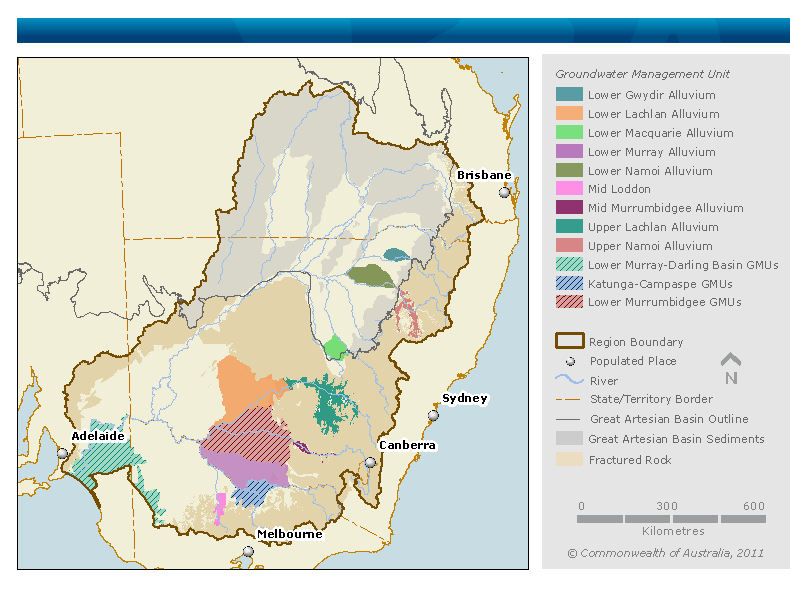
Figure P11. Map of groundwater management units considered for calculations in the the 2010 Account (source for boundaries of the MDB region and GMUs: Australian Government Department of Sustainability, Environment, Water, Population and Communities, and Murray–Darling Basin Authority)
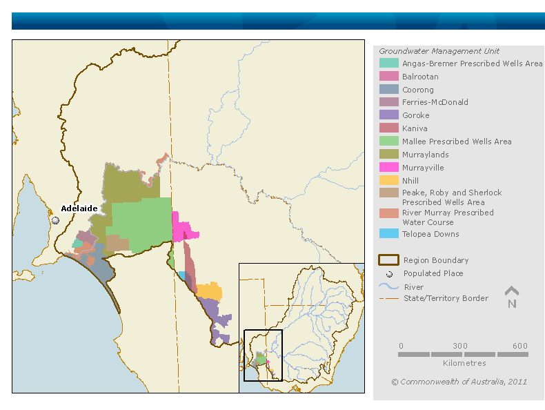
Figure P12. Map of the groundwater management units (GMUs) grouped by the 2010 Account into the lower Murray–Darling Basin GMUs (source for boundaries of the MDB region and GMUs: Australian Government Department of Sustainability, Environment, Water, Population and Communities, and Murray–Darling Basin Authority)
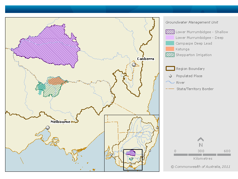
Figure P13. Map of the groundwater management units (GMUs) grouped by the 2010 Account into the Lower Murrumbidgee GMUs and Katunga–Campaspe GMUs (source for boundaries of the MDB region and GMUs: Australian Government Department of Sustainability, Environment, Water, Population and Communities, and Murray–Darling Basin Authority)
In most fractured rock areas of the MDB (see Figure P11), groundwater use is limited to stock and domestic supply. Furthermore, in fractured rock areas, the annual change in groundwater storage and annual groundwater flow out of the area is much less significant to regional water balance. A groundwater balance in these areas is not explicitly estimated in the 2010 Account.
The GAB contains confined aquifers at depth and the confining layers at or near the land surface. It underlies about one-third of the MDB in the northwest (Figure P11). The GAB is a large geological basin that extends beyond the MDB drainage basin boundary to the north and west. It is recharged in small areas of the MDB (along the southeastern edge of the GAB) where the aquifer layers are exposed at the land surface. The GAB is not considered to be part of the MDB water balance because the GAB aquifers are effectively hydraulically disconnected from near-surface systems in the MDB. Groundwater extraction and leakage from the GAB to the MDB are not represented in the 2010 Account, but may be represented in the future as an interbasin transfer.
In the areas where the GAB confining layer is near or at the land surface (shown in Figure P11 as part of the area identified as ‘Great Artesian Basin Sediments’), storage is limited to the near-surface soil zone and is lost from this zone almost entirely as evapotranspiration. Thus there is no need to evaluate change in groundwater storage in these areas to establish an annual regional water balance in the MDB. In the areas overlaying the GAB – where the confining layer does not outcrop – there are some shallow alluvial areas associated with drainage lines. These were also not considered in the water balance evaluation.
Groundwater was explicitly quantified only for the GMUs that had the largest volumes of water stored and where extraction was substantial (see figures P11 to P13, above).
More details about the groundwater resources within the MDB region are available in the Groundwater note.
Across the MDB region, many towns and urban centres return treated urban wastewater to the river for subsequent use downstream. For example, on the Murrumbidgee, average returns to connected surface water from Canberra are more than half of the Australian Capital Territory diversions from the river. Returns may also flow from irrigation channels and infrastructure back to the rivers.
National Water Account 2010
Related links
Water links
