The volume recognised in the water accounting statements (143,063 ML) represents the estimated total net volume of water recharged to groundwater from the landscape in 2009–10.
The volume of water recharged to groundwater from the landscape is calculated by the Water Atmosphere Vegetation Energy and Solutes (WAVES) model allowing for the effect of shallow water tables where they occur. Shallow watertables typically reduce the total net recharge and in some cases a net recharge can be negative (that is, a positive discharge of groundwater to the soil and atmosphere).
Bureau of Meteorology, National Climate Centre (NCC): version 3 daily rainfall grids; version 3 annual rainfall grids; daily maximum temperature grids; daily minimum temperature grids; daily satellite observed solar radiation grids; daily vapour pressure deficit grids.
Australian Soil Resources Information System (ASRIS): soil information, CSIRO.
Bureau of Rural Sciences: Water 2010, land use mapping.
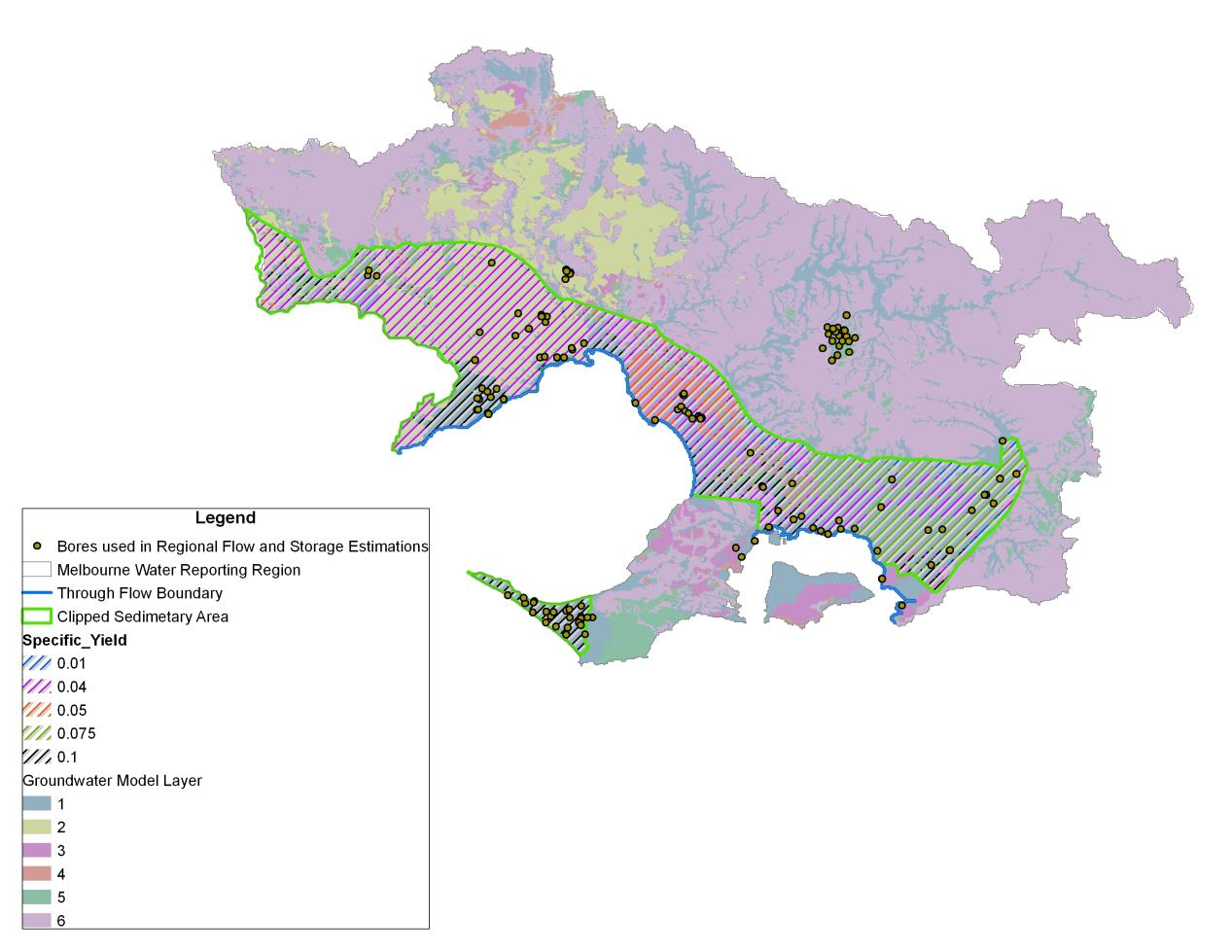
Victorian Department of Sustainability and Environment: bore locations and groundwater levels data within Port Phillip and Western Port catchment management authorities.
Bureau of Meteorology.
Groundwater recharge and discharge was estimated using the WAVES model (Zhang and Dawes 1998; Dawes et al. 1998). WAVES is a one-dimensional soil–vegetation–atmosphere–transfer model that integrates water, carbon and energy balances with a consistent level of process detail. The input data-sets required for WAVES include climate, depth to watertable, soil and vegetation data. The clipped sedimentary area (see the figure below) was selected for the estimation of net recharge. The climate data used at selected points include rainfall, rainfall duration, maximum and minimum temperatures, vapour pressure deficit, and solar radiation. The relevant vegetation parameters required for modelling were selected from the WAVES user manual (Dawes et al. 1998). WAVES uses the soil hydraulic model of Broadbridge and White (1998) with saturated hydraulic conductivity, saturated moisture content, residual moisture content, inverse capillary length scale and an empirical constant as input parameters calculated from soil properties accessed in the ASRIS database (Johnston et al. 2003).
The WAVES model has been used by CSIRO in its Sustainable Yields projects (Crosbie et al. 2008) and the Bureau of Meteorology built on this methodology. WAVES was run for all combinations of soil, vegetation and depth to watertable at each climate point. A groundwater recharge value was estimated for each 5 km × 5 km pixel across the region using annual rainfall, dominant soil and vegetation, and depth to watertable.
The net recharge within the selected region was estimated based on spatial interpolation of recharge estimates between values at nearby climate points.
Ungraded. The uncertainty in the input parameters and the corresponding impacts on the modelled recharge values have not been studied. The uncertainty of the estimated recharge resulting from different recharge interpolation methods is not estimated.
National Water Account 2010
Related links
Water links
