Summary
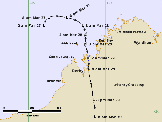
A monsoon trough developed to the north of Western Australia in late March associated with an active phase of the Madden-Julian Oscillation. Aided by the passage of an Equatorial Rossby Wave, a tropical low (28U) formed within the monsoon trough to the northwest of the Kimberley in the early hours of 27 March.
The tropical low moved east towards the Kimberley coast during 27 March. Gales developed initially on the northern side overnight into 28 March and it continued to strengthen quickly as a small system, becoming Tropical Cyclone Dianne that afternoon. As it strengthened it turned south, crossing the coast near Koolan Island as a category 2 tropical cyclone early in the morning of 29 March. Near storm force winds were recorded at Koolan Island as Dianne crossed with a maximum gust of 62 knots (115 km/h) recorded at 1823 UTC 28 March (02:23 AWST 29 March).
Heavy rainfall was also observed through parts of the western Kimberley with Derby Airport recording 153 mm in the 24 hours to 9am on 29 March, including 133 mm in the six hours between 3am and 9am 29 March.
As it moved inland, Dianne quickly weakened again but continued to bring rainfall to inland parts of the Kimberley and North Interior.
Tropical Cyclone Dianne was the 10th tropical cyclone in the Australian region for the 2024/25 season.
For more information see the TC Dianne Report (doc).
Track and Intensity