Summary
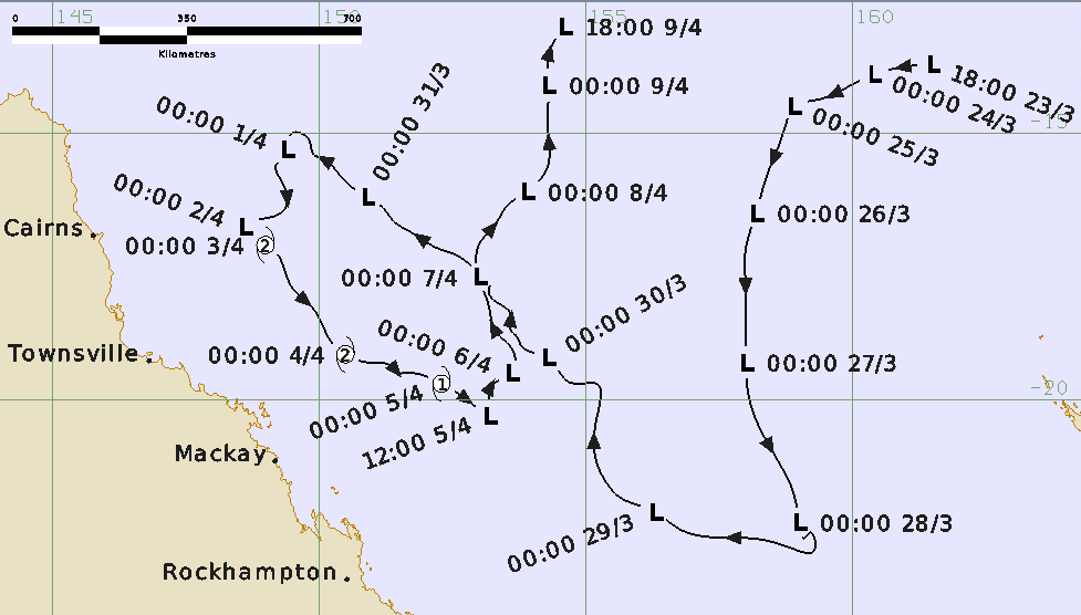
Tropical Cyclone Iris was a long-lived tropical disturbance that performed a looping traversal of the Coral Sea during late March and early April 2018 as shown in Figure 1 and Figure 2. Iris was at tropical cyclone intensity from 2-5 April off the Queensland coast and produced gales over the Whitsunday Islands and hazardous surf conditions along the central and southern Queensland coast.
A tropical low was first identified over the eastern Solomon Islands on 20 March, On 23 March, the system consolidated northwest of Vanuatu and began to intensify as it moved westward. It was named Iris by the Fiji Meteorological Service early on 24 March, however it was not estimated to have been a tropical cyclone as it crossed 160°E into the Australian region.
Over the following five days the system tracked to the southwest then south over the eastern Coral Sea. On 28 March the low took a turn to the west northwest in response to a strong ridge to the south. Despite minimal deep convection, a small region of gales were observed on 29 March but well away from the circulation south of the centre. The strong southeasterly winds generated large waves and hazardous surf on the Queensland coast that closed beaches from K'gari (Fraser Island) to the Gold Coast for the Easter long weekend (30 March-2 April).
The low moved rapidly northwest for a few days. On 1 April the system slowed and deep convection increased signalling intensification. Flinders Reef commenced recording gales early on 2 April and continued for 43 hours. The system was reanalysed to be at tropical cyclone intensity overnight from 2 to 3 April quickly attaining category 2 intensity on the evidence of observed winds at Flinders Reef.
Iris moved southeast roughly parallel to the Queensland coast while maintaining category 2 intensity for the next 2 days. It made its closest approach to the coast, 210 km northeast of Hamilton Island in the Whitsundays, on the morning of 4 April. Hamilton Island recorded a period of gales and maximum wind gusts to 106 km/h.
Iris began to weaken during 4 April, being estimated below tropical cyclone intensity late on 5 April. The low then turned towards the north and eventually dissipated south of Papua New Guinea on 9 April.
For more information see the TC Iris Report (docx).
Track and Intensity