Summary
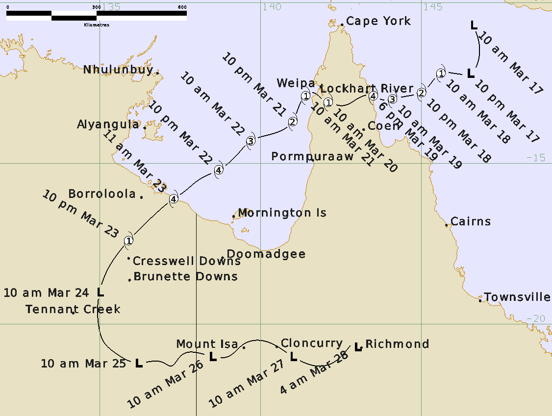
Trevor initially formed in the northwest Coral Sea on 17 March before rapidly intensifying into a severe tropical cyclone and reaching category 4 intensity prior to crossing the far north Queensland coast, south of Lockhart River, at around 6pm AEST on 19 March.
As the cyclone crossed the coast, the community of Lockhart River was subjected to approximately four hours of destructive (i.e. category 2) winds with peak gusts of up to 137 km/h recorded at the airport. These winds caused damage to buildings and uprooted trees around Lockhart River with heavy rain leading to flooding and road closures across Cape York.
Trevor remained a category 1 system as it moved westwards across Cape York before it emerged over Gulf of Carpentaria waters, near Weipa, on 21 March. Trevor turned towards the southwest and quickly re-intensified as it moved across the Gulf and towards the Northern Territory coast over the next couple of days. The cyclone reached category 4 intensity with estimated wind gusts of 260 km/h before it crossed the Northern Territory coast, between Port McArthur and the Queensland border around 11am ACST on 23 March. The strongest wind gust recorded in the Northern Territory was 139 km/h early on 23 March at Centre Island, near Port McArthur (equivalent to category 2 intensity). Gales were reported for several hours at Borroloola as the cyclone passed on 23 March.
The cyclone moved inland across the Carpentaria and Barkly districts before weakening into a tropical low early on 24 March near Creswell Downs. The low continued south through the eastern Northern Territory before moving across northwest Queensland from 26 March.
In the Northern Territory, the cyclone passed between Borroloola and Robinson River with little damage in those communities apart from felled trees. A fishing camp south of Borroloola sustained damage to several houses and out-buildings. A storm surge affected the southern Gulf of Carpentaria coast but caused little damage in a mostly unpopulated area. The tide gauge at Burketown, 300km east of landfall, recorded a surge of 1.8m, while Mornington Island recorded a 1.7m surge. More than 2000 people were evacuated to Darwin and Katherine from Alyangula, Borroloola, Numbulwar and Ngukurr in advance of Trevor making landfall in the Northern Territory.
The most widespread impact from the system was the heavy rainfall in drought-ravaged areas in eastern parts of the Northern Territory and northern and central Queensland. Some sites had their highest March daily rainfall on record or their highest total March rainfall in several decades. Localised flooding cut many roads in these districts, including the Tablelands, Sandover and Plenty Highways, and Tobermorey Station near the NT/Queensland border was inundated by floodwaters from the Sandover River.
For more information see the TC Trevor Report.
Track and Intensity