Summary
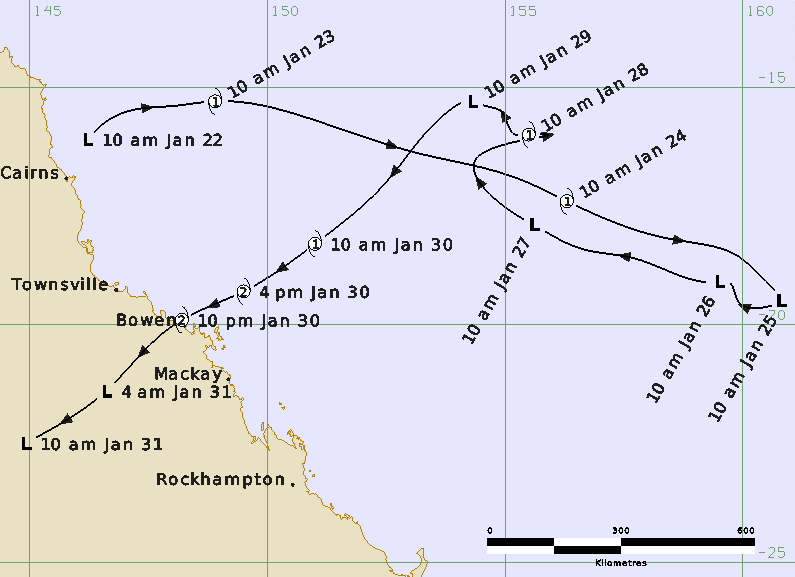
Tropical Cyclone Anthony was a Coral Sea event that crossed the Queensland coast near Bowen at category 2 intensity late on 30 January. A tropical low was initially analysed in the northwest Coral Sea, northeast of Cairns on 22 January. The low quickly developed reaching tropical cyclone intensity on 23 January and then accelerated to the southeast away from the Queensland coast. Increased wind shear weakened the system below cyclone intensity on 25 January. The low then made an abrupt turn to the northwest and then re-intensified into a category 1 tropical cyclone for 12 hours on 28 January. Anthony then weakened once more and began to adopt a southwesterly track on 29 January towards the central Queensland coast which continued through to landfall.
>Anthony re-intensified into a category 1 cyclone on the morning of 30 January, further intensifying into a category 2 system prior to making landfall near Bowen just before 10pm AEST on 30 January. Impacts were considered relatively minor. A total of 11,415 homes were reported to have lost power in Bowen, Airlie Beach, Mackay Collinsville and Sarina. Around Bowen, the Whitsundays and as far south as Mackay there were numerous reports of damage to vegetation, but only minor damage to buildings. A boat sunk outside Bowen marina and six boats broke their moorings at Airlie Beach marina. Townsville and Mackay were pre-emptively declared disaster areas to aid recovery response and the ports at Townsville, Mackay, Hay Point and Abbott Point were closed.
For more information see the TC Anthony Report (doc).
Track and Intensity(Time in AEST (UTC+10h))