Summary
Severe Tropical Cyclone Courtney developed to the north of Western Australia and moved westwards, leaving the Australian area of responsibility on 29 March. Courtney remained well away from the Australian mainland and island communities throughout its life and caused no direct impacts.
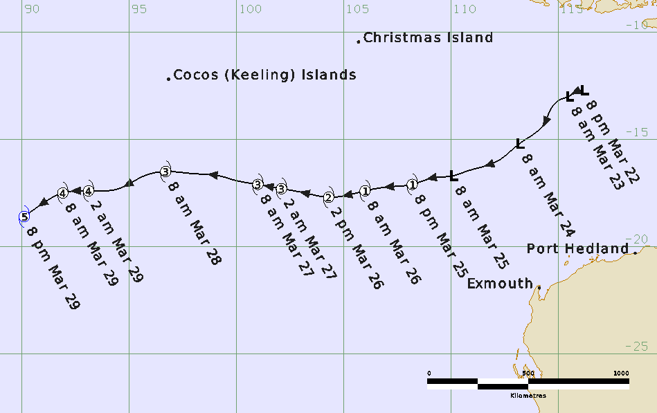
An active phase of the Madden-Julian Oscillation affected Western Australian longitudes during the second half of March. Tropical Low 27U gradually coalesced out of the monsoon trough well north of the Pilbara coastline and was first trackable on 22 March. Development was slow initially as the broad circulation remained close to or under a region of strong easterly deep layer wind shear. 27U moved generally to the west-southwest steered by a mid-level ridge to the south, which remained the dominant steering influence for the next week.
By 24 March, atmospheric conditions had improved, and the system consolidated and strengthened. 27U first reached tropical cyclone intensity for a short period from the evening of 24 March until the morning of 25 March, however it was not named operationally at this time. An increase in deep layer wind shear saw the system weaken below tropical cyclone intensity during 25 March, before consolidating once more overnight as conditions again improved. Courtney attained tropical cyclone intensity early on 26 March. For the next several days it was steered steadily west through open waters of the Indian Ocean while continuing to intensify. On the morning of 28 March, it passed approximately 480 kilometres to the south of the Cocos (Keeling) Islands at category 3 strength, which was its closest approach to any inhabited community. On the evening of 29 March, Courtney reached a lifetime peak 10-minute mean wind intensity of 110 kn (205 km/h) just prior to moving out of the Australian area of responsibility.
There were no impacts to the Australian mainland or Island communities from this system.
For more information see the TC Courtney Report (docx).
Track and Intensity