Summary
Severe Tropical Cyclone Errol was a compact but intense system that underwent a period of rapid intensification, reaching category 5 strength off the Western Australian coast, before weakening and making landfall to the south of Kuri Bay as a tropical low.
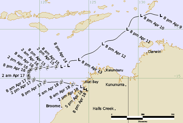
A tropical low, 29U, formed on 9 April in the northern Arafura Sea. It initially tracked westward and then to the southwest, fluctuating in intensity over several days, passing within 250 km of the north Kimberley coast for the first time on 13 April. After a period of steady development, Errol reached tropical cyclone intensity at 0600 UTC 15 April (1400 AWST 15 April, AWST = UTC+8 hours). Extremely rapid intensification occurred on 15-16 April, with Errol strengthening from a 35 kn (65km/h) category 1 system to a 110 kn (205 km/h) category 5 system in 30 hours. Errol peaked around 1200 UTC 16 April (2000 AWST 16 April) with 10-minute sustained winds of 110 kn (205 km/h) and wind gusts of 155 kn (285 km/h).
On 17 April, Errol turned sharply to the southeast and weakened rapidly over the next day as it tracked eastwards towards the north Kimberley coast. Errol weakened below tropical cyclone intensity prior to crossing the coast to the south of Kuri Bay around 0900 UTC 18 April (1700 AWST 18 April). The remnants of the system continued to weaken and dissipate over the north Kimberley.
Impacts were limited due to the cyclone’s small size and remote landfall location. Heavy rainfall occurred through parts of the coastal north Kimberley as Errol approached the coast, with Koolan Island recording 68.8 mm in the 24 hours to 0900 AWST on 18 April. This heavy rainfall spread into the inland north Kimberley as the remnants of the system moved inland the following day. Kalumburu recorded 160.8 mm of rainfall in the 24 hours to 0900 AWST 19 April, which was the highest daily rainfall record for April for this station. No locations on the mainland recorded damaging wind gusts. Errol crossed over Adele Island in the hours prior to crossing the coast, with the weather station recording a peak wind gust of 55kn (102 km/h) and a lowest atmospheric pressure of 994.2 hPa.
For more information see the TC Errol Report (doc).
Track and Intensity (Time in AWST)