Summary
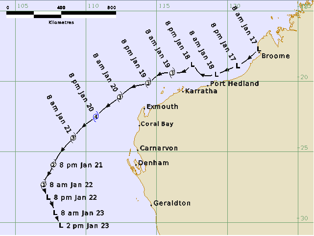
A tropical low (11U) formed west of the Kimberley coast on 17 January where near record sea surface temperatures contributed to a very favourable environment for tropical cyclone development. Another tropical low (10U) nearby initially hampered the development of 11U, but 10U steadily dissipated, allowing 11U to strengthen. As 11U developed it was steered to the west-southwest, parallel to the Pilbara coast. It reached tropical cyclone intensity and was named Tropical Cyclone Sean at 0000 UTC (8:00am AWST) 19 January while to the north of Karratha. Sean continued to intensify quickly, reaching category 3 strength by 1200 UTC 19 January.
Sean turned southwest and reached a peak intensity of 95 knots (175 km/h) at 1200 UTC 20 January while it was located about 350 km to the west of Exmouth. From 1800 UTC 20 January Sean began to weaken as it moved over cooler sea surface temperatures. Sean stayed well to the west of the Western Australian coast as it continued to weaken and had lost its tropical characteristics by 0600 UTC 22 January.
Gales were observed along the Pilbara coast between Roebourne and Exmouth during 19 and 20 January with a maximum wind gust of 56 knots (104 km/h) recorded at Karratha at 0829 UTC 19 January. Karratha also exceeded its highest annual daily rainfall record when 274 mm of rain fell in the 24 hours to 9 am 20 January, including an intense rainband that moved across the town during the late afternoon and early evening of 19 January. Residents reported water ingress and flooding, as well as trees down on properties and cars.
A combination of a shelf wave and storm surge generated tides of about 0.6 to 1.2 m above normal along the Pilbara and west coasts.
Severe Tropical Cyclone Sean was the second tropical cyclone and the first severe tropical cyclone in the Australian region for the 2024/25 season.
For more information see the TC Sean Report (doc).
Track and Intensity