Summary
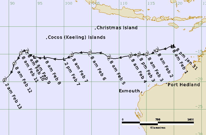
Severe Tropical Cyclone Taliah (14U) was a long-lived event that tracked west across the eastern Indian Ocean experiencing multiple peaks in intensity throughout its lifetime.
Tropical low 14U formed northwest of the Kimberley coast late on 31 January and developed steadily over following days as it tracked to the west southwest. 14U reached tropical cyclone intensity at 0000 UTC 2 February (0800 WST 2 February, WST=UTC+8 hours) well north of the Pilbara coast. Taliah continued its west to west-southwest track and reached a 10-minute mean wind peak intensity of 75 kn (140 km/h) between 0000 – 0600 UTC 4 February.
From late on 4 February the combined influences of increased vertical wind shear and dry air being entrained into the circulation weakened Taliah. During 7 February Taliah weakened below tropical cyclone intensity, however gales persisted north of the centre, assisted by the monsoon flow, until 8 February. Between 1200 UTC 8 February and 1800 UTC 9 February there were no gales present around Taliah. Conditions then became more favourable with a decrease in vertical wind shear and Taliah re-intensified into a tropical cyclone at 0000 UTC 10 February. Taliah continued to intensify and crossed 90°E late on 12 February at an intensity of 60 kn (110 km/h), moving out of the Australian area of responsibility. Taliah then weakened very gradually over following days as it moved southwest over the central Indian Ocean.
Taliah did not impact the Australian mainland or island communities.
For more information see the TC Taliah Report (doc).
Track and Intensity