This page provides details about the region, its water resources, land use and water-related infrastructure.
Area: 21,000 km² (Department of Natural Resources & Mines, 2005; Department of Natural Resources, Mines & Water 2006a; Department of Natural Resources, Mines & Water 2006b)
Population: 2,614,000 (ABS 2010)
The South East Queensland (SEQ) region is located on the southeast coast of Queensland (Figure P1) and is physically defined by the following hydrological boundaries:
This region does not include Stradbroke Island, Bribie Island, the Sunshine Coast or Toowoomba.
The SEQ region spreads from the New South Wales–Queensland state border in the south, the Pacific Ocean in the east, the top of the Great Dividing Range in the west and the headwaters of the Brisbane River in the north (Figure P2). Mountains exist along the west and southern edge of the SEQ region with coastal plains in the east. The region contains several large, coastal discharging rivers.
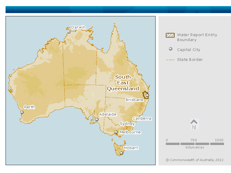
Figure P1. Location map of the South East Queensland region within Australia
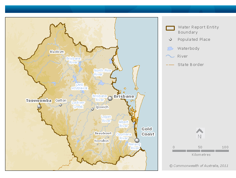
Figure P2. Contextual map of the South East Queensland region
Table P1. Major catchments within the South East Queensland region
| Major catchment | Catchment area (km²) |
Water Resource Plan (WRP) area |
|---|---|---|
| Coomera River | 440 | Gold Coast |
| Nerang River | 501 | |
| Pimpama River | 175 | |
| Tallebudgera and Currumbin Creek | 158 | |
| Albert River | 786 | Logan Basin |
| Logan River | 3,077 | |
| Tingalpa Creek, Redlands Creek and Eprapah Creek | 281 | |
| Brisbane River | 14,040 | Moreton |
| Caboolture River | 468 | |
| North and South Pine Rivers | 825 | |
| Pumicestone Creek | 789 |
Source: Healthy waterways website
The SEQ region is physically defined in the section above, and includes all water resources within or beneath the physical area.
The SEQ region includes water stored in:
The SEQ region excludes:
The major towns and cities in the South East Queensland (SEQ) region are shown in Table P2.
Table P2. Major population centres within the South East Queensland region
| Locality | Population |
|---|---|
| Brisbane | 1,052,000 |
| Gold Coast | 515,000 |
| Logan City | 277,000 |
| Ipswich | 162,000 |
Source: ABS 2010
A number of small towns are interspersed throughout the rest of the region including Gatton, Beaudesert, Kilcoy and Kooralbyn.
South East Queensland is the most densely populated area of Queensland. Water use is predominately urban around Brisbane and the Gold Coast, with irrigated agriculture being a major water user within the rural portion of the region.
Table P3 and Figure P3 show that grazing and conservation are the largest land uses in the SEQ region and that water intensive land use in the region is predominantly irrigated agriculture and urban (Department of Natural Resources & Mines, 2005; Department of Natural Resources, Mines & Water 2006a; Department of Natural Resources, Mines & Water 2006b). Major agricultural products include dairy, fodder crops, cereal and horticultural crops.
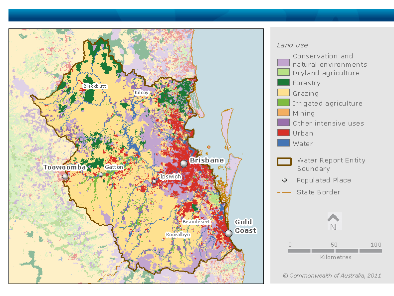
Figure P3. Map of land use in the South East Queensland region
Table P3. Land use in the South East Queensland region
| Land use | Area (km2) | Area (%) |
|---|---|---|
| Conservation and natural environments | 3,267 | 16 |
| Grazing | 11,777 | 56 |
| Forestry | 1,541 | 7 |
| Dryland agriculture | 233 | 1 |
| Irrigated agriculture | 639 | 3 |
| Urban | 2,402 | 11 |
| Other intensive uses | 795 | 4 |
| Mining | 3 | <0.1 |
| Water | 443 | 2 |
| Total SEQ region | 21,100 | 100 |
Source: ABRS 2010
The South East Queensland (SEQ) region contains 12 nationally important wetlands, listed in the Directory of Important Wetlands in Australia. Further information can also be found on the Department of Environment and Resource Management Wetland information site.
The wetlands of Moreton Bay, adjacent to the region and effected by outflows from the region, are listed as Ramsar wetlands. They cover in excess of 11,000 km², most of which is on coastal islands or near shore marine areas. The habitat ranges from perched freshwater lakes and sedge swamps on the offshore sand islands, to intertidal mudflats, marshes, sandflats and mangroves next to the Bay’s islands and the mainland.
Surface water makes up the majority of water resources use within the South East Queensland (SEQ) region, with groundwater usage limited to various alluvial aquifers located along river valleys. Desalinated water and recycled water are also used within the SEQ region, with usage of these resources increasing in recent years.
The overall surface water resource is highly developed in the SEQ region, with surface water management plans in place across the entire region. Groundwater resources within the region are becoming more developed, with groundwater management areas (GMA) now present across many high use alluvial aquifers. It is expected that additional GMA may be introduced as further development of groundwater occurs.
Agriculture and urban settlements are the main water users within the SEQ region. Reservoir storage in the region is mainly for urban use. Recycled water and desalinated water supplement the surface and groundwater resources, for urban use and use in power supply.
The Water Regulations 2008 stipulate that major storages have a maximum storage capacity greater than 1,000 ML. In addition to the major storages listed in Table P4 and Figure P4, numerous public storages with a storage capacity less than 1,000 ML exist within South East Queensland, athough they are not included in this account. It is estimated that these storages have a combined capacity in excess of 7,000 ML.
Table P4. Major reservoirs in the South East Queensland region
| Water Resource Plan (WRP) area | Water Supply Scheme (WSS) | Storage name | Total storage capacity
4
(ML) |
Total dead storage
5
(ML) |
|---|---|---|---|---|
| Gold Coast | Nerang | Advancetown Lake (Hinze Dam) | 161,073 | 0 |
| Little Nerang Dam | 6,705 | 0 | ||
| Total Gold Coast WRP area | 167,778 | 0 | ||
| Logan Basin | Logan River | Bromelton off-stream storage² | 8,210 | 0 |
| Cedar Grove Weir² | 1,144 | 0 | ||
| Lake Maroon | 44,319 | 0 | ||
| None | Tingalpa Reservoir (Leslie Harrison Dam) | 24,868 | 0 | |
| Total Logan Basin WRP area | 78,541 | 0 | ||
| Moreton | Central Brisbane and Stanley | Mount Crosby Weir³ | 3,430 | 0 |
| Lake Wivenhoe | 1,165,238 | 0 | ||
| Lake Somerset | 379,849 | 0 | ||
| Central Lockyer | Lake Clarendon | 24,276 | 0 | |
| Lake Dyer (Bill Gunn Dam) | 6,947 | 0 | ||
| Cressbrook Creek | Lake Cressbrook² | 81,842 | 1,136 | |
| Lake Perseverance² | 30,140 | 3,472 | ||
| Lower Lockyer | Lake Atkinson (Atkinson Dam) | 30,400 | 0 | |
| Pine Valley | Lake Samsonvale (North Pine Dam) | 214,302 | 0 | |
| Warrill Valley | Lake Moogerah | 86,290 | 0 | |
| None | Enoggera Reservoir | 4,567 | 0 | |
| Gold Creek Reservoir | 1,436 | 0 | ||
| Lake Kurwongbah (Sideling Creek Dam) | 14,370 | 0 | ||
| Lake Manchester (Cabbage Tree Creek Dam) | 25,951 | 0 | ||
| Splityard Creek Dam² | 28,700 | 6,400 | ||
| Total Moreton WRP area | 2,097,738 | 11,008 | ||
| Total South East Queensland region | 2,344,057 | 11,008 | ||
Table notes:

Figure P4. Map of surface water infrastructure within the South East Queensland region
The South East Queensland (SEQ) Water Grid was established in July 2008 to connect water supplies and treatment facilities across the SEQ region. The SEQ Water Grid connects the water infrastructure of the region through a series of two-way pipes that enable transfer of water within the SEQ region, and between the region and neighbouring areas. This provides coordinated management of water resources. Further information on the SEQ Water Grid can be found at the Water Grid webpage or Seqwater webpage. Water retailers within the SEQ region can be seen in Figure P5.
Located outside the SEQ region, Toowoomba obtains raw water directly from reservoirs on Cressbrook and Perseverance Creeks which are within the region. Potable water is supplied into the SEQ region from the Sunshine Coast (via the Northern Pipeline Interconnector) and Stradbroke Island.

Figure P5. Map of Council retailers (2009-10) and water utilities (2010-11) within South East Queensland
Figure P6 shows mean monthly flow volumes in four main rivers within the SEQ region – Albert, Bremer, Brisbane and Logan Rivers. Gauging stations on these rivers can be seen in Figure P7. These rivers generally have flow throughout the year; however most of the flow within these catchments occurs from December to June.
The seasonal flow characteristics of these rivers reflect the rainfall pattern of the SEQ region, where a large proportion of rainfall occurs from December to March.
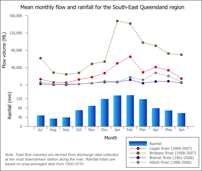
Figure P6. Graph of mean monthly flows along the Albert, Brisbane, Bremer and Logan Rivers; mean monthly rainfall for the region is also shown
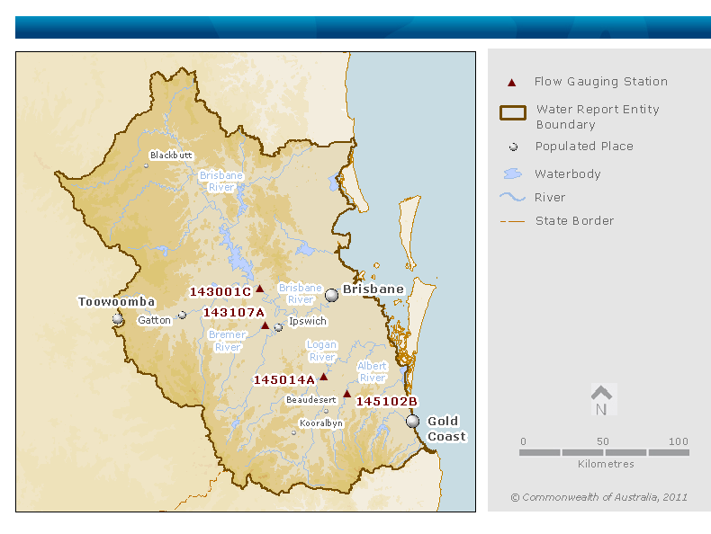
Figure P7. Map of key flow gauging stations along the main rivers within the South East Queensland region
Groundwater extracted from alluvial aquifers is the primary source of water for the irrigation dominated Lockyer Valley. Groundwater use is minor in the south of the South East Queensland (SEQ) region, with sub-artesian water taken from local aquifers for agricultural and domestic uses. Shallow bores are used to access groundwater for garden watering on the coastal plain.
There are three groundwater management areas (GMAs) within the SEQ region: Lockyer Valley, Warrill Bremer Alluvial and Cressbrook Alluvial GMAs.The three GMAs are all located within the Moreton water resource plan (WRP) area. Due to the unavailability of data, only the Lockyer Valley GMA was included as a water store in this report.
Desalinated water from the Gold Coast Desalination Plant feeds directly into the SEQ Water Grid. With the South East Queensland (SEQ) region’s dams full or near full, the Gold Coast Desalination Plant has been operating in ‘hot standby’ mode to minimise operating costs since December 2010. Under this mode of operation, the plant will typically produce around 25 ML/d of water two days a week, with no production in between. This small amount of production is needed to keep the membranes wet and the water in the pipes fresh, while retaining the capacity to ramp up to produce 44 ML/d (33%), 88 ML/d (66%) or 133 ML/d (100%) within hours whenever required.
The plant may be called on if there are interruptions to supply in other parts of the SEQ Water Grid, as occurred in the January 2011 floods and in lighting strikes that temporarily knocked out the Mount Crosby water treatment plant. The plant will also cover production when other parts of the SEQ Water Grid are off line for routine maintenance.
Two main recycled water schemes exist within the South East Queensland (SEQ) region.
Within the SEQ region Class A+ recycled water is supplied to 3,700 homes and businesses in the Pimpama Coomera area of the Gold Coast for toilet flushing and external non-drinking use. Industry also receives recycled water.
The Recycled Water Treatment Plant is part of the Pimpama Coomera Waterfuture Master Plan. The Pimpama Coomera recycled water system was not included in this account as data were not available to quantify the volumes with any confidence.
The Western Corridor Recycled Water Project forms part of the SEQ Water Grid and supplies the Swanbank Power Station (CS Energy) with recycled water. Tarong and Tarong North Power Station (Tarong Energy), located outside the SEQ region, are also provided with water from the Western Corridor Recycled Water Project.
The Western Corridor Recycled Water Project has a capacity of 232 ML/d.
Currently the power stations are the only users of the Western Corridor Recycled Water Project.
National Water Account 2010
Related links
Water links
