Rainfall update
Inviting your feedback on our climate information
We are running a short survey to understand how you use the climate information pages on our website. Your feedback will help us improve services and shape future products that better support your needs. Please use our Feedback Form to participate.
Recent rainfall station totals
Alternative mobile version
About these data, maps and tables
- Maps and tables use real-time rainfall data, and limited quality control has been performed
- Some stations occasionally report multi-day accumulations, which may show up as high daily, weekly or month-to-date totals.
- Daily data are updated at and available around .
- Weekly data are updated at AEDT each day and available around .
- Monthly data are published around on the last day each month, then updated after midnight on the 2nd, 3rd and 22nd of the following month.
- Month periods use monthly totals, and have additional information, including 'Years of data', 'Mean' and 'Percentile' rainfall for the selected period. Percentiles are calculated for stations with at least 20 years of data; newer stations show N/A in map popups and -1.00 in the table view. Percentiles are expressed as a number out of 100. The percentile refers to the ranking of a particular value relative to all of the values for that site.
- Elevation is listed as -999 in the table when not available
- In the tables, select Station number to open rainfall table, or elsewhere in row to show on map
- Popups from the map, and Station numbers in the table, link to more rainfall information. In the tables, periods with daily data link to the latest year of daily rainfall values, and month periods link to the full station history of monthly data.
- More about rainfall data
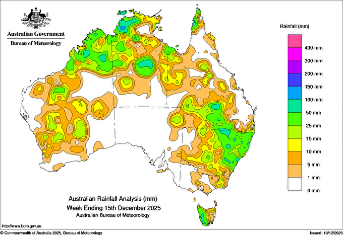
Weekly highlights
Thunderstorms and rainfall impacted the tropical north and parts of the east
- Daily showers and thunderstorms impacted the tropical north and parts of Western Australia throughout the week.
- Weekly rainfall totals of 25 to 100 mm, and locally higher totals, were recorded across northern parts of Western Australia, north-western and central parts of the Northern Territory, and parts of tropical Queensland.
- A low-pressure trough across the north-east, combined with tropical air and an upper disturbance triggering widespread showers and thunderstorms, some severe, across large parts of eastern Australia later in the week.
- Weekly rainfall totals of 25 to 100 mm were recorded across much of eastern and northern parts of New South Wales and southern Queensland.
- Cold fronts and associated troughs brought scattered showers and thunderstorms across parts of the south-east during the week.
- Weekly rainfall totals of 25 to 100 mm were recorded across much western Tasmania.
- The highest weekly total (at a Bureau gauge) was 195.0 mm at Tipperary in the Northern Territory, which included the highest daily total of 119.0 mm in the 24 hours to 9 am on 13 December.

Product code: IDCKGRWAR0
History
Previous rainfall reports
![]() Unless otherwise noted, all maps, graphs and diagrams in this page are licensed under the Creative Commons Attribution 4.0 International Licence
Unless otherwise noted, all maps, graphs and diagrams in this page are licensed under the Creative Commons Attribution 4.0 International Licence


