Tuesday 27 January 2026 - Annual Climate Summary for Northern Territory - Product code IDCKGC52R0
Northern Territory in 2025
Rainfall
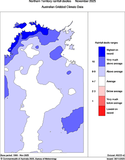
- Rainfall totals in 2025 were above to very much above average for northern and eastern parts of the Northern Territory, and below average for the far south-western corner of the Northern Territory.
- The Northern Territory's area-averaged rainfall total in 2025 was 579.4 mm, 6% above the 1961–1990 average.
- It was the driest year in Northern Territory since 2021.
- Jabiru Council and Middle Point had their highest daily rainfall on record.
- Port Keats Airport and Middle Point had their highest total annual rainfall on record.
Temperature
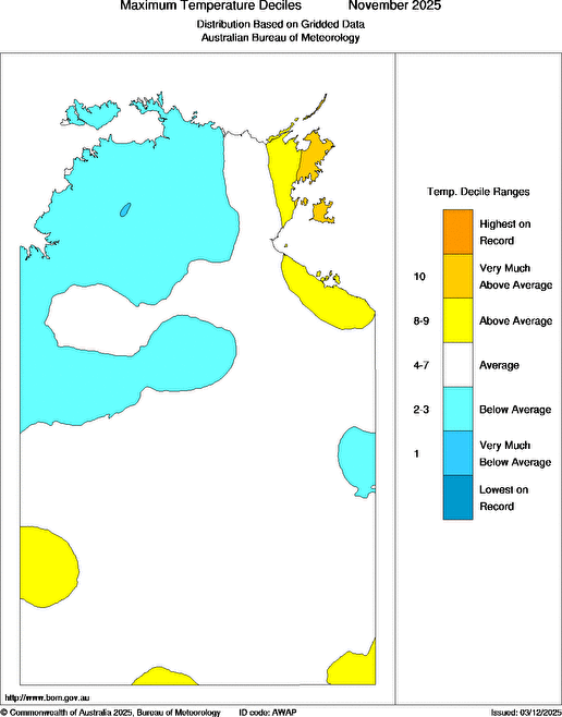
- Mean maximum temperatures in 2025 were above to very much above average across most of the Northern Territory.
- The Northern Territory's area-averaged mean maximum temperature was 33.0 °C, 1.08 °C above the 1961–1990 average, the ninth-warmest on record for all years since 1910.
- The Northern Territory had its highest mean maximum temperature for the year since 2020.
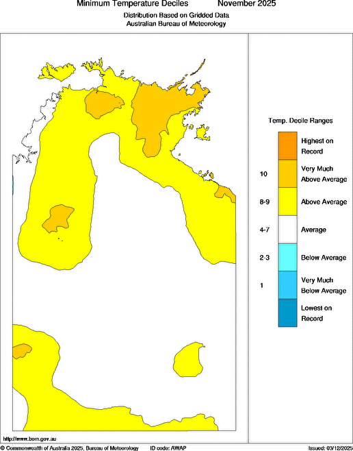
- Mean minimum temperatures in 2025 were above to very much above average for most of the northern, eastern and southern Northern Territory, and the highest on record for part of the south-west of the Northern Territory.
- The Northern Territory's area-averaged mean minimum temperature was 19.2 °C, 0.71 °C above the 1961–1990 average.
- The Northern Territory had its lowest mean minimum temperature for the year since 2023.
- Dum In Mirrie Airstrip recorded its equal warmest night (highest daily minimum temperature) on record on 3 February.
- Tennant Creek Airport recorded its coldest night (lowest daily minimum temperature) on record on 4 August.
- The Northern Territory's area-averaged mean temperature was 26.1 °C, 0.90 °C above the 1961–1990 average.
Darwin Airport
- Total rainfall for Darwin Airport was 2297.8 mm, which is 133% of the long-term average of 1725.6 mm.
- The mean daily maximum temperature for Darwin Airport was 32.8 °C, which is 0.7 °C above the long-term average of 32.1 °C.
- The warmest day was 38.4 °C on the 4 Oct 2025, and the coolest day was on the 22 Nov 2025 when the temperature reached 26.3 °C.
- The mean daily minimum temperature for Darwin Airport was 23.6 °C, which is 0.4 °C above the long-term average of 23.2 °C.
- The coldest morning was 14.9 °C on the 4 Jul 2025, and the warmest morning was on the 3 Feb 2025 when the minimum temperature was 30.0 °C.
Alice Springs Airport
- Total rainfall for Alice Springs Airport was 257.8 mm, which is 91% of the long-term average of 283.7 mm.
- The mean daily maximum temperature for Alice Springs Airport was 30.3 °C, which is 1.4 °C above the long-term average of 28.9 °C.
- The warmest day was 44.6 °C on the 27 Jan 2025, and the coolest day was on the 28 May 2025 when the temperature reached 11.3 °C.
- The mean daily minimum temperature for Alice Springs Airport was 13.4 °C, which is 0.2 °C above the long-term average of 13.2 °C.
- The coldest morning was -2.1 °C on the 2 Aug 2025, and the warmest morning was on the 12 Feb 2025 when the minimum temperature was 30.9 °C.
Extremes Maps Records Summaries Important notes the top
| Extremes in 2025 | |
|---|---|
| Hottest day |
46.2 °C at Jervois on 27 January |
| Warmest days on average |
35.8 °C at Bradshaw - Angallari Valley (Defence) |
| Coolest days on average |
30.3 °C at Alice Springs Airport |
| Coldest day |
11.2 °C at Watarrka on 27 May |
| Coldest night |
-2.1 °C at Alice Springs Airport on 2 August |
| Coolest nights on average |
13.4 °C at Alice Springs Airport |
| Warmest nights on average |
24.5 °C at Warruwi Airport |
| Warmest night |
33.5 °C at Walungurru Airport on 2 February |
| Warmest on average overall |
29.1 °C at Bradshaw - Angallari Valley (Defence) |
| Coolest on average overall |
21.9 °C at Alice Springs Airport |
| Wettest overall |
2380.6 mm at Knuckey Lagoon |
| Wettest day |
430.0 mm at Middle Point on 23 November |
| Strongest wind gust |
137.0 km/h at Territory Grape Farm on 2 November |
Extremes Maps Records Summaries Important notes the top
| Maps | |||
|---|---|---|---|
| Observed | Anomaly | Decile rank | |
| Total rainfall |
 |
 |
 |
| Mean daily maximum temperatures |
 |
 |
 |
| Mean daily minimum temperatures |
 |
 |
 |
Click on a map to show it full size in a pop-up window
| Monthly maps | |||
|---|---|---|---|
| Rainfall rank | Maximum temperature rank | Minimum temperature rank | |
| January |

|

|

|
| February |

|

|

|
| March |

|

|

|
| April |

|

|

|
| May |

|

|

|
| June |

|

|

|
| July |

|

|

|
| August |

|

|

|
| September |

|

|

|
| October |

|

|

|
| November |

|

|

|
| December |

|

|

|
Click on a map to show it full size in a pop-up window
Extremes Maps Records Summaries Important notes the top
| Record highest year daily rainfall | ||||||
|---|---|---|---|---|---|---|
| New record (mm) |
Old record |
Years of record |
Average for year |
|||
| Jabiru Council | 340.0 | on 8 March | 151.2 | on 23 Dec 1997 | 23 | 1465.3 |
| Middle Point | 430.0 | on 23 November | 142.0 | on 15 Feb 2011 | 23 | 1399.0 |
| Record highest year total rainfall | |||||
|---|---|---|---|---|---|
| New record (mm) |
Old record |
Years of record |
Average for year |
||
| Port Keats Airport | 2029.4 | 1926.8 | in 2014 | 26 | 1222.9 |
| Middle Point | 2137.0 | 1934.8 | in 2011 | 24 | 1323.0 |
| Record highest year daily minimum temperature | ||||||
|---|---|---|---|---|---|---|
| New record (°C) |
Old record |
Years of record |
Average for year |
|||
| Dum In Mirrie Airstrip | 30.4 | on 3 February | =30.4 | on 27 Dec 2019 | 28 | 23.3 |
| Record lowest year temperature | ||||||
|---|---|---|---|---|---|---|
| New record (°C) |
Old record |
Years of record |
Average for year |
|||
| Tennant Creek Airport | 4.1 | on 4 August | 4.5 | on 14 Jul 1978 | 57 | 19.9 |
Extremes Maps Records Summaries Important notes the top
| Summary statistics for 2025 | ||||||||||||
|---|---|---|---|---|---|---|---|---|---|---|---|---|
| Maximum temperatures (°C) |
Minimum temperatures (°C) |
Rainfall (millimetres) |
||||||||||
| Mean for year 2025 |
Diff from average |
Highest for year 2025 |
Mean for year 2025 |
Diff from average |
Lowest for year 2025 |
Total for year 2025 |
Average for year |
Rank of year 2025 |
Fraction of year average |
|||
| Darwin-Daly (district 14GA) | ||||||||||||
| Batchelor Airport | 33.5 | -0.3 | 40.1 | 4 Oct 2025 | 21.5 | +0.2 | 10.5 | 4 Jul 2025 | 1958.6 | 1529.2 | high | 128% |
| Central Arnhem Plateau | 38.1 | 24 Oct 2025 | 9.3 | 11 Aug 2025 | 1522.0 | 1212.0 | high | 126% | ||||
| Channel Point | 36.0 | 15 Oct 2025 | 14.1 | 2 Jul 2025 | 2265.8 | 1794.6 | high | 126% | ||||
| Charles Point | 31.6 | 0.0 | 35.6 | 4 Oct 2025 | 24.0 | -0.2 | 16.8 | 4 Jul 2025 | 1816.8 | 1548.4 | high | 117% |
| Darwin Airport | 32.8 | +0.7 | 38.4 | 4 Oct 2025 | 23.6 | +0.4 | 14.9 | 4 Jul 2025 | 2297.8 | 1725.6 | high | 133% |
| Delamere Weapons Range | 34.3 | +0.3 | 41.4 | 1 Jan 2025 | 21.0 | 0.0 | 7.9 | 4 Aug 2025 | 1225.4 | 888.8 | high | 138% |
| Douglas River Research Farm | 34.3 | -0.2 | 39.7 | 4 Oct 2025 | 20.2 | +0.2 | 6.2 | 4 Aug 2025 | 1435.8 | 1248.7 | high | 115% |
| Dum In Mirrie Airstrip | 32.8 | +0.8 | 37.4 | 23 Sep 2025 | 23.0 | -0.3 | 13.5 | 16 Jun 2025 | 2190.6 | 1778.9 | high | 123% |
| East Point | 32.3 | 38.0 | 4 Oct 2025 | 23.9 | 15.6 | 4 Jul 2025 | 2218.8 | |||||
| Jabiru Airport | 34.6 | +0.1 | 40.1 | 4 Oct 2025 | 23.3 | +0.5 | 14.1 | 12 Aug 2025 | 1651.6 | 1539.1 | average | 215% |
| Kangaroo Flats (Defence) | 34.4 | 40.7 | 4 Oct 2025 | 22.6 | 12.9 | 4 Jul 2025 | 1961.6 | |||||
| Knuckey Lagoon | 33.3 | 38.8 | 4 Oct 2025 | 22.4 | 11.7 | 11 Aug 2025 | 2380.6 | |||||
| Middle Point | 34.1 | -0.4 | 40.3 | 3 Oct 2025 | 21.5 | +0.8 | 10.2 | 20 Aug 2025 | 2137.0 | 1388.5 | highest | 154% |
| Mount Bundey North (Defence) | 40.2 | 4 Oct 2025 | 14.9 | 6 Aug 2025 | 1293.4 | |||||||
| Mount Bundey South (Defence) | 34.4 | 40.7 | 4 Oct 2025 | 21.9 | 10.6 | 20 Aug 2025 | 1292.4 | |||||
| Murganella Airstrip | 32.8 | -0.2 | 38.0 | 29 Oct 2025 | 21.5 | 0.0 | 8.0 | 11 Aug 2025 | 1901.0 | |||
| Noonamah Airstrip | 40.8 | 4 Oct 2025 | 10.8 | 4 Jul 2025 | 1836.4 | 1532.2 | high | 120% | ||||
| Oenpelli Airport | 34.3 | 39.9 | 4 Oct 2025 | 23.1 | 11.3 | 11 Aug 2025 | 1152.8 | 1401.1 | average | 82% | ||
| Pirlangimpi Airport | 33.2 | +0.6 | 38.4 | 2 Oct 2025 | 15.0 | 12 Aug 2025 | 1094.6 | 1988.9 | lowest | 55% | ||
| Point Stuart | 32.8 | -0.2 | 37.2 | 28 Oct 2025 | 22.9 | +0.1 | 12.9 | 11 Aug 2025 | 1701.2 | 1327.4 | high | 128% |
| Port Keats Airport | 33.0 | -0.1 | 39.2 | 4 Oct 2025 | 22.1 | +0.1 | 10.9 | 5 Aug 2025 | 2029.4 | 1332.0 | highest | 152% |
| Tindal RAAF | 34.5 | +0.3 | 41.2 | 23 Oct 2025 | 7.1 | 3 Aug 2025 | 1117.6 | 1064.0 | average | 105% | ||
| Arnhem (district 14BC) | ||||||||||||
| Gove Airport | 31.2 | 36.2 | 29 Nov 2025 | 23.6 | 15.9 | 11 Aug 2025 | 1981.4 | |||||
| Groote Eylandt Airport | 32.2 | 0.0 | 38.0 | 28 Oct 2025 | 22.0 | +1.0 | 10.4 | 5 Aug 2025 | 1228.8 | 1302.1 | average | 94% |
| Maningrida Airport | 32.2 | -0.2 | 36.5 | 4 Oct 2025 | 22.8 | +0.2 | 13.0 | 15 Jun 2025 | 1373.8 | 1230.4 | high | 112% |
| Milingimbi Airport | 36.6 | 4 Oct 2025 | 23.2 | 0.0 | 13.3 | 11 Aug 2025 | 1447.0 | 1203.4 | high | 120% | ||
| Ngayawili | 31.5 | -0.1 | 37.6 | 4 Oct 2025 | 23.6 | +0.5 | 13.2 | 11 Aug 2025 | 772.8 | 1388.6 | v low | 56% |
| Warruwi Airport | 31.5 | +0.1 | 36.7 | 1 Nov 2025 | 24.5 | +0.1 | 17.6 | 12 Aug 2025 | 1543.4 | 1137.7 | high | 136% |
| Roper-Mcarthur (district 14DE) | ||||||||||||
| Borroloola Airport | 34.6 | +0.5 | 43.0 | 20 Jan 2025 | 20.1 | +0.4 | 4.9 | 14 Jun 2025 | 934.0 | 885.8 | average | 105% |
| Bulman | 34.6 | -0.3 | 41.3 | 28 Oct 2025 | 20.4 | -0.2 | 6.5 | 15 Jun 2025 | 1063.0 | 1058.5 | average | 100% |
| Centre Island | 31.2 | -0.1 | 38.6 | 19 Jan 2025 | 24.4 | +0.5 | 15.8 | 5 Aug 2025 | 1231.0 | 1039.8 | high | 118% |
| Daly Waters Airstrip | 42.4 | 2 Feb 2025 | 1.3 | 4 Aug 2025 | 707.2 | 690.0 | average | 102% | ||||
| McArthur River Mine Airport | 35.2 | +0.4 | 42.7 | 20 Jan 2025 | 20.3 | +0.4 | 4.6 | 21 Jul 2025 | 790.8 | 776.1 | average | 102% |
| Ngukurr Airport | 42.3 | 23 Oct 2025 | 6.8 | 3 Aug 2025 | 975.4 | 741.3 | high | 132% | ||||
| Victoria (district 14F) | ||||||||||||
| Bradshaw | 35.6 | 0.0 | 41.7 | 23 Oct 2025 | 21.4 | -0.5 | 7.5 | 4 Aug 2025 | 983.6 | 1022.8 | average | 96% |
| Bradshaw - Angallari Valley (Defence) | 35.8 | 42.7 | 28 Oct 2025 | 22.5 | 9.5 | 4 Aug 2025 | 728.2 | |||||
| Bradshaw - Koolendong Valley (Defence) | 35.0 | 41.8 | 4 Dec 2025 | 19.7 | 3.9 | 4 Aug 2025 | 1045.6 | |||||
| Lajamanu Airport | 34.5 | +0.6 | 43.2 | 2 Feb 2025 | 19.0 | +0.7 | 3.3 | 3 Aug 2025 | 470.4 | 526.9 | average | 89% |
| Victoria River Downs | 35.8 | +1.1 | 42.9 | 3 Jan 2025 | 20.0 | +0.4 | 4.7 | 3 Aug 2025 | 766.6 | 657.7 | high | 117% |
| Barkly (district 15A) | ||||||||||||
| Elliott | 42.2 | 31 Oct 2025 | 2.0 | 9 Jul 2025 | 663.2 | 603.3 | average | 110% | ||||
| Tennant Creek Airport | 32.8 | +0.7 | 42.9 | 3 Mar 2025 | 20.1 | +0.2 | 4.1 | 4 Aug 2025 | 398.2 | 484.3 | average | 82% |
| Alice Springs (district 15B) | ||||||||||||
| Alice Springs Airport | 30.3 | +1.4 | 44.6 | 27 Jan 2025 | 13.4 | +0.2 | -2.1 | 2 Aug 2025 | 257.8 | 283.7 | average | 91% |
| Curtin Springs | 45.7 | 1 Mar 2025 | -1.5 | 23 Jul 2025 | 61.3 | 237.6 | v low | 26% | ||||
| Jervois | 31.7 | +0.6 | 46.2 | 27 Jan 2025 | 15.8 | +1.0 | -1.3 | 3 Aug 2025 | 406.2 | 287.8 | high | 141% |
| Rabbit Flat | 34.7 | +0.8 | 44.9 | 3 Mar 2025 | 16.6 | 0.0 | -1.4 | 30 Jun 2025 | 311.4 | 495.3 | low | 63% |
| Walungurru Airport | 33.1 | +0.3 | 46.2 | 26 Jan 2025 | 19.7 | +0.2 | 5.1 | 26 Jul 2025 | 241.0 | 289.8 | low | 83% |
| Watarrka | 44.0 | 1 Mar 2025 | -0.8 | 24 Jun 2025 | 289.7 | 307.8 | average | 94% | ||||
| Yulara Airport | 31.2 | +1.0 | 45.3 | 1 Mar 2025 | 15.4 | +1.2 | -2.1 | 23 Jul 2025 | 185.0 | 270.0 | average | 69% |
Extremes Maps Records Summaries Important notes the top
Notes
The Annual climate summary, usually published in the first week of the following month, lists the main features of the weather in Northern Territory using the most timely and accurate information available on the date of publication; it will generally not be updated.
This statement has been prepared based on information available on Tuesday 27 January 2026. Some checks have been made on the data, but it is possible that results will change as new information becomes available.
In some situations, some or all of the rainfall is in the form of hail or snow. In these cases, the totals given are for the water equivalent: the depth of liquid water that results from melting any frozen precipitation. There can be significant 'undercatch' of snow in strong winds, meaning the true precipitation can be higher than that reported.
Averages for individual sites are long-term means based on observations from
all available years of record, excluding the current year. The length of record can
vary widely from site to site. Averages are not shown for sites with fewer than
10 years of record, as they cannot then be calculated reliably.
The median
is sometimes more representative than the
mean
of long-term average rain.
The Rank indicates how rainfall this time compares with the climate record for the site,
based on the
decile ranking
(very low rainfall is in decile 1, low in decile 2 or 3,
average in decile 4 to 7, high in decile 8 or 9
and very high is in decile 10).
The Fraction of average shows how much rain has fallen this time as a
percentage of the long-term mean.
Where temperature area averages are mentioned, they are derived from the ACORN-SAT dataset.
Information about Australian Indigenous seasonal calendars is available at the Indigenous Weather Knowledge website.
![]() Unless otherwise noted, all maps, graphs and diagrams in this page are licensed under the Creative Commons Attribution 4.0 International Licence
Unless otherwise noted, all maps, graphs and diagrams in this page are licensed under the Creative Commons Attribution 4.0 International Licence


