


Climate Model Summary Archive: 25 July 2012
Issued on Wednesday 25 July 2012 | Product Code IDCKGLM000
El Niño remains likely in 2012
Summary
After a brief easing of the warming trend towards El Niño thresholds over the last few months (as detailed in the ENSO Wrap-Up), some further warming of sea surface temperatures in the tropical Pacific has taken place in the past fortnight.
All dynamical models surveyed by the Bureau of Meteorology suggest that sea surface temperatures in the tropical Pacific will continue to warm, approaching or exceeding El Niño thresholds sometime after mid-winter 2012. However, results from individual models continue to show a moderate to high level of spread in their forecasts, meaning there continues to be a range of potential scenarios. Some models surveyed have eased their outlooks slightly since last month, suggesting weaker or later-forming El Niño conditions. Climatologists will continue to monitor conditions and outlooks closely for any further developments over the coming months.
Model Outlooks
The following table summarises the opinion of National Climate Centre (NCC) climatologists regarding the outputs from various long range forecast models. The model set contains seven reputable ocean or coupled ocean/atmosphere climate models that take into account complex physical ocean processes. NCC's interpretation may not necessarily be the same as the organisations producing the model output. You are therefore encouraged to follow the hyperlinks to the various institutions listed in the table.
See About ENSO outlooks for details on the models and a summary of the terms used.
| MODEL / GROUP |
Forecast Start Date | 1-3 MONTHS (Aug 2012 to Oct 2012) |
4-6 MONTHS (Nov 2012 to Jan 2013) |
|---|---|---|---|
| POAMA Australian Bureau of Meteorology |
1 July | Neutral/Warm | Neutral/Warm |
| CFS NCEP (US) |
23 July | Neutral/Warm | Warm |
|
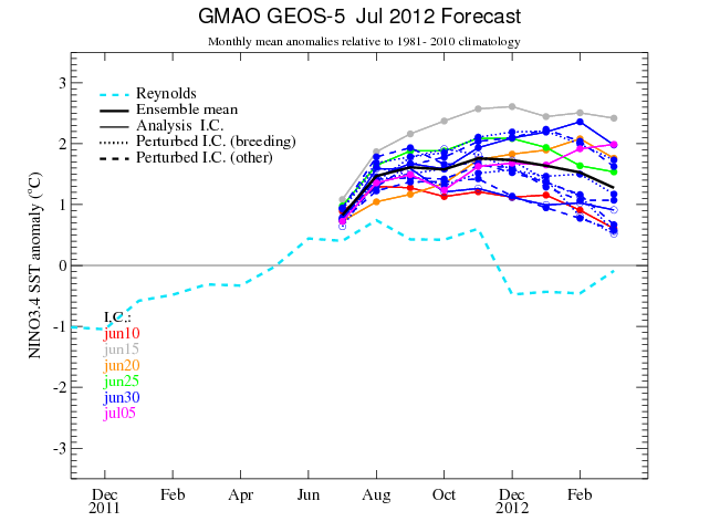
GEOS-5 NASA Goddard GMAO (US) |
1 July | Warm | Warm |
|
System 4 ECMWF (EU) |
1 July | Neutral/Warm | Warm |
|
JMA/MRI-CGCM Japan Met. Agency |
1 July | Warm | Warm |
|
GloSea UK Met Office |
1 July | Warm | Warm # |
|
ARPEGE* MeteoFrance |
1 July | Neutral/Warm | Neutral/Warm |
# Forecast is for November and December only.
* This model has been introduced to our Model Summary as of 16 May 2012. A password is required to view these forecasts.
POAMA Forecasts
The POAMA model, run at the Bureau of Meteorology, generates a new forecast on day 1 of each month for the following eight months. The most recent model run predicts NINO3.4 will continue to warm over the next few months, approaching the El Niño threshold in August-September. POAMA suggests NINO3.4 will then remain near the +0.8 threshold until the end of the austral summer.
The IOD index remains neutral with the most recent value of 0.2 for the week ending 22nd July. Recent forecasts from the POAMA model predict the IOD will remain neutral during the austral winter and spring.
September 2012
The most recent POAMA model run (1 July) predicts the average
NINO3.4 temperature anomaly for September 2012 will be +0.8 °C and the frequency distribution
is as follows:
below −0.8 °C: 0.0% (Cool)
−0.8 °C to +0.8 °C: 43.3% (Neutral)
above +0.8 °C: 56.7% (Warm)
December 2012
For December 2012, the average NINO3.4 temperature anomaly is +0.8 °C and
the frequency distribution is as follows:
below −0.8 °C: 0.0% (Cool)
−0.8 °C to +0.8 °C: 50.0% (Neutral)
above +0.8 °C: 50.0% (Warm)
Similar data for other months can be accessed by following the "POAMA" link in the table above.
Users should exercise caution when interpreting these forecasts and are encouraged to view the actual model outputs by following the web links. Frequent updates of the latest observational data with relevant commentary are available on the Bureau's ENSO Wrap-Up page.
This survey last updated on the 25th of July 2012.
Next update expected 8th of August 2012.
See also the ENSO Wrap-up archive here.
Past climate model summaries
- October 2015 El Niño to peak towards end of 2015; rapid decay likely in first quarter of 2016
- September 2015 El Niño set to persist at strongest values since 1997-98
- August 2015 Models maintain El Niño into 2016
- July 2015 El Niño likely to strengthen and persist through 2015
- June 2015 El Niño likely to strengthen during spring.
- May 2015 Models indicate tropical Pacific to remain well above El Niño thresholds.
- April 2015 Models maintain outlooks for El Niño through winter and spring.
- March 2015 Model consensus indicates El Niño by winter 2015.
- February 2015 ENSO neutral, though tropical Pacific Ocean likely to remain warm.
- January 2015 Models suggesting neutral for now, but remaining warm.
- December 2014 Tropical Pacific Ocean likely to remain near El Niño thresholds over summer.
- November 2014 Models near El Niño thresholds.
- October 2014 Models ease outlooks for El Niño in summer.
- September 2014 El Niño remains on hold.
- August 2014 Models ease their El Niño outlook for spring.
- July 2014 Majority of models still favour spring El Niño.
- June 2014 El Niño remains likely for 2014.
- May 2014 El Niño remains likely for 2014.
- April 2014 Models suggest El Niño likely by mid-winter.
- March 2014 An increased chance of El Niño from winter.
- February 2014 Models indicate tropical Pacific to warm.
- January 2014 Models suggest tropical Pacific likely to warm over coming months.
- December 2013 Neutral ENSO through summer.
- November 2013 Neutral ENSO through summer.
- October 2013 Neutral ENSO for austral summer.
- September 2013 ENSO and IOD neutral.
- August 2013 ENSO neutral; negative IOD weakening.
- July 2013 ENSO remains neutral; negative IOD likely
- June 2013 Negative IOD, but ENSO remains neutral.
- May 2013 Neutral ENSO, possible negative IOD development.
- April 2013 Neutral ENSO conditions expected to persist.
- March 2013 ENSO neutral set to continue.
- February 2013 Models predict neutral conditions to continue.
- 19 September 2012 Pacific remains close to El Niño thresholds.
- 5 September 2012 Borderline El Niño conditions continue.
- 22 August 2012 El Niño remains likely for 2012.
- 8 August 2012 Models predict weak El Niño in 2012.
- 25 July 2012 El Niño remains likely in 2012.
- 11 July 2012 Models suggest increased risk of El Niño in 2012.
- 27 June 2012 Models suggest further warming through winter.
- 13 June 2012 Models suggest further warming through winter.
- 30 May 2012 Neutral in tropical Pacific, but further warming likely.
- 16 May 2012 Warming in tropical Pacific set to continue.
- 2 May 2012 Neutral conditions, but warming in tropical Pacific continues.
- 18 April 2012 Continued warming in tropical Pacific Ocean.
- 4 April 2012 La Niña ends; conditions neutral.
- 26 October 2011 La Niña re-established in the Pacific.
- 27 April 2011 Models predict neutral conditions by southern hemisphere winter.
- 30 March 2011 Models predict continued weakening of La Niña conditions.
- 2 March 2011 Models predict continued weakening of La Niña conditions.
- 2 February 2011 Models predict La Niña will persist into the southern hemisphere autumn.
- 18 January 2011 Models predict La Niña event will persist through southern hemisphere summer.
- 8 November 2010 Models predict La Niña event will persist into first quarter of 2011.
- 27 October 2010 Models predict La Niña event will persist into at least early 2011.
- 13 October 2010 Models predict La Niña event likely to continue until at least early 2011.
- 29 September 2010 Models predict La Niña event to continue through 2010.
- 15 September 2010 Models predict La Niña conditions to continue: La Niña intensifies in the Pacific.
- 1 September 2010 Models predict conditions to remain above La Niña thresholds: La Niña strengthens in the Pacific.
- 18 August 2010 Models predict continued cooling in the tropical Pacific: La Niña conditions persist in the Pacific.
- 31 May 2010 Models predict neutral conditions to persist over coming months, with the possibility of cool conditions later in the year.
- April 2010 Models predict neutral conditions to persist over coming months, with the possibility of cool conditions later in the year.
- March 2010 Models predict neutral conditions to return to the Pacific by June 2010.
- November 2009 Models predict that El Niño conditions will persist through summer 2009/10.
